Filter: Categories of Wisconsin Historical Images
Filter: Subject of Rivers
Filter: Creator Name of Unknown
Filter: Categories of Wisconsin Historical Images
Filter: Subject of Rivers
Filter: Creator Name of Unknown

| Date: | |
|---|---|
| Description: | A car advertisement for a 1966 Chevelle on a billboard in a small unidentified Appalachian town. |
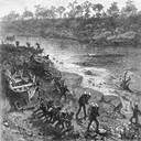
| Date: | 1879 |
|---|---|
| Description: | Lithograph of voyageurs making a portage from an article on "The Honorable Hudson Bay Company" from Harpers Monthly in 1879. |
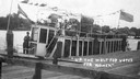
| Date: | 1912 |
|---|---|
| Description: | Suffragists sitting aboard the Mary E. at dockside on the Wolf River. The boat sports a banner reading: "Votes for Women." |
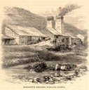
| Date: | 05 1866 |
|---|---|
| Description: | Engraved exterior view of a smelting furnace with a small group of men with horses gathered in front. |

| Date: | 1876 |
|---|---|
| Description: | Bird's-eye view of Black Earth. |
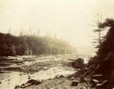
| Date: | |
|---|---|
| Description: | Wanigans tied to the banks of the St. Croix River among floating logs. |
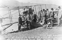
| Date: | 10 19 1911 |
|---|---|
| Description: | Pilot Hugh Robinson and his Curtiss hydroplane at Prairie du Chien during a flight that was intended to be the first all the way down the Mississippi River... |

| Date: | 1910 |
|---|---|
| Description: | Map of Dane County rural delivery in Madison and the town of Westport. |

| Date: | 1839 |
|---|---|
| Description: | A map of the Wiskonsin [sic] and Neenah or Fox Rivers. |

| Date: | 1910 |
|---|---|
| Description: | Map of the general plan of the district of the Four Lakes. |

| Date: | 1923 |
|---|---|
| Description: | Map of Oneida County-Rhinelander Airport which was laid out at the county fairgrounds. The map appears on the reverse side of a letter Roy Larson received ... |

| Date: | 1836 |
|---|---|
| Description: | The top map is the "Plat of Madison the Capitol of Wisconsin." The bottom map is the "Map of the Four Lake Country. Taken from the Township Maps in the U.S... |
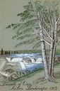
| Date: | 1973 |
|---|---|
| Description: | Cover for the Wisconsin Friends of Our Native Landscape program. Depicted is a river cascading over rocks, and some trees in the foreground. The Wisconsin ... |

| Date: | 2007 |
|---|---|
| Description: | This map of Cedarbug is a bird's-eye map with 8 inset views and an index. The map is a print out of the original map dated 1892 held at the Cedarburg Cultu... |

| Date: | 1874 |
|---|---|
| Description: | Bird's-eye map of Chippewa Falls. |

| Date: | 1874 |
|---|---|
| Description: | Bird's-eye map of Lodi, with inset of Public School. Includes index of churches and points of interest. |

| Date: | 1868 |
|---|---|
| Description: | Bird's-eye map of Manitowoc, with four insets. Manitowoc County. |

| Date: | 1905 |
|---|---|
| Description: | Bird's-eye view of Manitowoc on the shores of Lake Michigan. A map of the northeastern part of the United States at the top indicates Manitowoc's location ... |
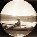
| Date: | 05 09 1894 |
|---|---|
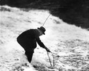
| Description: | Reuben Gold Thwaites rowing the skiff the "Pilgrim" on the Ohio River. |
If you didn't find the material you searched for, our Library Reference Staff can help.
Call our reference desk at 608-264-6535 or email us at: