 Filter: Categories of Wisconsin Historical Images
Filter: Subject of Reservoirs
Filter: Categories of Wisconsin Historical Images
Filter: Subject of Reservoirs
| Date: | 09 25 1922 |
|---|---|
| Description: | The reservoir bulkhead and watershed for the Edward Hableman cranberry marshes. The reservoir was part of the irrigation system used to flood the cranberry... |

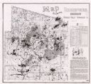
| Date: | 1930 |
|---|---|
| Description: | This map shows Indian trails through Wisconsin counties. The trail are in red ink. Lake Michigan, Green Bay, Lake Superior, and the Wisconsin River are lab... |
| Date: | 1924 |
|---|---|
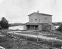
| Description: | The Humbird Roller Mill surrounded by rural landscape. A man leads on a porch beam as he poses for the picture. |

| Date: | 1939 |
|---|---|
| Description: | This nine-part map from the U.S. Bureau of Public Roads identifies federal and state highways in Wisconsin by pavement type. County, forest, park, and publ... |
| Date: | 1935 |
|---|---|
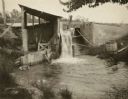
| Description: | Five women pose at the dam built by Frank Lloyd Wright at his home near Spring Green, Wisconsin. A sixth figure is obscured by tree branches on the right. ... |

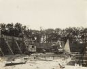
| Date: | |
|---|---|
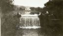
| Description: | Elevated view from hill looking down at a river and reservoir. A railroad train is moving along railroad tracks on the opposite side of the river. Houses a... |
| Date: | |
|---|---|
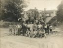
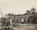
| Description: | The "O'Dea and Shafer, Engineers and Contractors" construction crew, posing with a piece of equipment. A house and trees are in the background. Bags of cem... |
| Date: | 1925 |
|---|---|
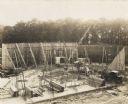
| Description: | A building site with "O'Dea and Shafer, Engineers and Contractors" construction crew, crane and other equipment. On the photograph album binding on the lef... |
| Date: | 1925 |
|---|---|
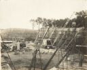
| Description: | Elevated view of a building site with "O'Dea and Shafer, Engineers and Contractors" construction crew, crane and other equipment. On the photograph album b... |
| Date: | 1925 |
|---|---|
| Description: | Elevated view of a building site with "O'Dea and Shafer, Engineers and Contractors" construction crew, crane and other equipment. On the photograph album b... |
| Date: | 1925 |
|---|---|
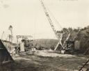
| Description: | A building site with "O'Dea and Shafer, Engineers and Contractors" crane and other equipment. On the photograph album binding on the left side of the photo... |
| Date: | 1925 |
|---|---|
| Description: | A building site with "O'Dea and Shafer, Engineers and Contractors" construction crew, crane and other equipment. On the photograph album binding on the lef... |

| Date: | 1939 |
|---|---|
| Description: | Reservoir used to store water for raising cranberries. A large group of people are walking around the perimeter towards automobiles parked in the distance.... |

| Date: | 1941 |
|---|---|
| Description: | This is map one of three maps that show trails, roads and fire lanes, utilities, resorts, submerged lakes, vegetation, flowage right lands, and timber righ... |
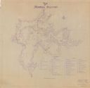
| Date: | 1987 |
|---|---|
| Description: | This map shows reservoirs, drainage areas, and parts of of Lincoln, Langlade, Forest, Oneida, and Vilas counties. Includes 1 inset map of corrections for R... |
| Date: | 1941 |
|---|---|
| Description: | This is map two of a set of three and shows boundaries and flowage right lands in red ink. A legend in the lower right corner includes a legend of symbols ... |

| Date: | 1941 |
|---|---|
| Description: | This is map three of a set of three, and shows trails, roads and fire lanes, utilities, resorts, submerged lakes, vegetation, flowage right lands, and timb... |

| Date: | 1879 |
|---|---|
| Description: | This map shows wards, sections, roads, lot and block numbers, subdivisions, and proposed streets. The inside cover includes hand written annotations that r... |

| Date: | 1912 |
|---|---|
| Description: | This blueprint manuscript map shows landownership, mills, railroad, churches, public buildings, the old cemetery, and the Chippewa River and Reservoir. The... |

| Date: | 1900 |
|---|---|
| Description: | Elevated view across river of McCormick Works. |
If you didn't find the material you searched for, our Library Reference Staff can help.
Call our reference desk at 608-264-6535 or email us at: