 Filter: Categories of Wisconsin Historical Images
Filter: Subject of Reservoirs
Filter: Subject of transportation
Filter: Categories of Wisconsin Historical Images
Filter: Subject of Reservoirs
Filter: Subject of transportation

| Date: | 1940 |
|---|---|
| Description: | Advertising poster for International trucks. Features a color illustration of a D-line truck hauling a large section of aqueduct with a reservoir in the ba... |

| Date: | 1930 |
|---|---|
| Description: | Aerial view of city, with Eau Claire River is in the foreground with Milwaukee railroad bridge at left. Gillette Rubber Co. plant is in center with Omaha r... |

| Date: | 02 06 1948 |
|---|---|
| Description: | Aerial view of west side, looking south along Glenway Street. Visible are the reservoir, Lake Wingra, Forest Hill and Resurrection Cemetery, Hoyt Park. Maj... |

| Date: | 02 06 1948 |
|---|---|
| Description: | Aerial photograph looking northwest across the reservoir on Glenway Street. Featured are Hoyt and Quarry Parks, Resurrection Cemetery. Major streets are Fr... |

| Date: | 02 06 1948 |
|---|---|
| Description: | Looking north along Glenway Street. Visible are the reservoir, Hoyt and Quarry Parks, Resurrection and Forest Hill Cemeteries, Rentschler Greenhouses, Fore... |

| Date: | 02 06 1948 |
|---|---|
| Description: | Looking southeast across Speedway Road. Visible are the reservoir on Glenway Street, Hoyt Park, Resurrection and Forest Hill cemeteries, Glenway Golf cours... |

| Date: | 02 06 1948 |
|---|---|
| Description: | Looking east along Regent Street with snow on the ground. Visible are Lake Wingra, Monona Bay, railroad causeway across Monona, Lake Mendota, Hoyt Park, We... |
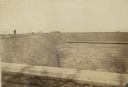
| Date: | 1900 |
|---|---|
| Description: | Reservoir, looking South, with pedestrians walking along the edge of the empty reservoir. A team of horses with a cart or wagon can also be seen in the bac... |
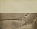
| Date: | 1900 |
|---|---|
| Description: | Looking down into the reservoir partially filled with water. A group of men stand at various levels; some with the carriage and horses at top, four on a le... |
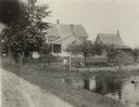
| Date: | 09 09 1922 |
|---|---|
| Description: | The farmhouse of the Wetherby Cranberry Company. At the time the farmhouse was owned by H. Kissinger. In the foreground is the corner of the water reservoi... |

| Date: | 1930 |
|---|---|
| Description: | This map shows Indian trails through Wisconsin counties. The trail are in red ink. Lake Michigan, Green Bay, Lake Superior, and the Wisconsin River are lab... |

| Date: | 1939 |
|---|---|
| Description: | This nine-part map from the U.S. Bureau of Public Roads identifies federal and state highways in Wisconsin by pavement type. County, forest, park, and publ... |

| Date: | |
|---|---|
| Description: | Elevated view from hill looking down at a river and reservoir. A railroad train is moving along railroad tracks on the opposite side of the river. Houses a... |
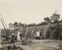
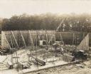
| Date: | 1925 |
|---|---|
| Description: | A building site with "O'Dea and Shafer, Engineers and Contractors" construction crew, crane and other equipment. On the photograph album binding on the lef... |
| Date: | 1925 |
|---|---|
| Description: | Elevated view of a building site with "O'Dea and Shafer, Engineers and Contractors" construction crew, crane and other equipment. On the photograph album b... |

| Date: | 1939 |
|---|---|
| Description: | Reservoir used to store water for raising cranberries. A large group of people are walking around the perimeter towards automobiles parked in the distance.... |

| Date: | 1941 |
|---|---|
| Description: | This is map one of three maps that show trails, roads and fire lanes, utilities, resorts, submerged lakes, vegetation, flowage right lands, and timber righ... |

| Date: | 1941 |
|---|---|
| Description: | This is map three of a set of three, and shows trails, roads and fire lanes, utilities, resorts, submerged lakes, vegetation, flowage right lands, and timb... |

| Date: | 1879 |
|---|---|
| Description: | This map shows wards, sections, roads, lot and block numbers, subdivisions, and proposed streets. The inside cover includes hand written annotations that r... |

| Date: | 1912 |
|---|---|
| Description: | This blueprint manuscript map shows landownership, mills, railroad, churches, public buildings, the old cemetery, and the Chippewa River and Reservoir. The... |
If you didn't find the material you searched for, our Library Reference Staff can help.
Call our reference desk at 608-264-6535 or email us at: