 Filter: Categories of Wisconsin Historical Images
Filter: Subject of Reservoirs
Filter: Subject of human settlements
Filter: Categories of Wisconsin Historical Images
Filter: Subject of Reservoirs
Filter: Subject of human settlements

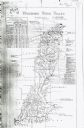
| Date: | 1941 |
|---|---|
| Description: | This is map three of a set of three, and shows trails, roads and fire lanes, utilities, resorts, submerged lakes, vegetation, flowage right lands, and timb... |

| Date: | 1879 |
|---|---|
| Description: | This map shows wards, sections, roads, lot and block numbers, subdivisions, and proposed streets. The inside cover includes hand written annotations that r... |

| Date: | 1912 |
|---|---|
| Description: | This blueprint manuscript map shows landownership, mills, railroad, churches, public buildings, the old cemetery, and the Chippewa River and Reservoir. The... |

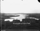
| Date: | 1900 |
|---|---|
| Description: | Elevated view across river of McCormick Works. |
| Date: | 1911 |
|---|---|
| Description: | This map includes references to reservoirs, industrial sites, and drainage basins. |

| Date: | 01 01 1959 |
|---|---|
| Description: | This map shows many of the rivers, dams, bays, harbors, lakes, and canals. It includes an index of authorized federal project, both for navigation and floo... |
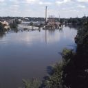
| Date: | |
|---|---|
| Description: | Elevated view over trees towards the Fox River. A dam is creating a reservoir for hydroelectric power. Former paper mills are on the left shore of the rive... |

| Date: | 1968 |
|---|---|
| Description: | Two ducks are silhouetted on the Chippewa Flowage at sunrise or sunset. |
| Date: | 1900 |
|---|---|
| Description: | Elevated view over the tops of buildings to the water beyond. A wooden sidewalk and fence runs along the street in the foreground. Caption on negative read... |
If you didn't find the material you searched for, our Library Reference Staff can help.
Call our reference desk at 608-264-6535 or email us at:
