 Filter: Categories of Wisconsin Historical Images
Filter: Subject of Recreation
Filter: Subject of wetlands
Filter: Categories of Wisconsin Historical Images
Filter: Subject of Recreation
Filter: Subject of wetlands

| Date: | 1902 |
|---|---|
| Description: | This 1902 map of the eastern portion of Sawyer County, Wisconsin, shows the township and range system, sections, roads, farm houses, camps, school houses, ... |

| Date: | 1975 |
|---|---|
| Description: | This map shows boundaries, roads, national forest land, bogs and wetlands, lakes, campgrounds, and boat landings. |

| Date: | 1720 |
|---|---|
| Description: | Detailed, ornate, and comprehensive map of America from the east coast to present day Texas. Numerous features appear throughout the map, including Native ... |
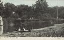
| Date: | 08 25 1911 |
|---|---|
| Description: | Text on front reads: "River Scene, Stoughton, Wis." Two women in a canoe on the Yahara River near wetlands foliage, with two people on the pedestrian bridg... |
If you didn't find the material you searched for, our Library Reference Staff can help.
Call our reference desk at 608-264-6535 or email us at: