 Filter: Categories of Wisconsin Historical Images
Filter: Subject of Recreation
Filter: Subject of international relations
Filter: Categories of Wisconsin Historical Images
Filter: Subject of Recreation
Filter: Subject of international relations
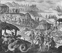
| Date: | 1655 |
|---|---|
| Description: | Scene from the Vespucci Expedition, 1499. |
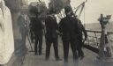
| Date: | 1917 |
|---|---|
| Description: | Members of the Root Commission trip to Russia playing "ship golf" on board the Buffalo. Original caption identifies the participants as: "Cyrus McCo... |
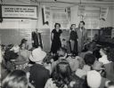
| Date: | |
|---|---|
| Description: | Ben Bergor, Madison magician, ventriloquist, and entertainment agent, performing with Jerry O'Reilly at a farm show. With Bergor is his wife Alva who often... |

| Date: | 1992 |
|---|---|
| Description: | Congressman David R. Obey (standing) of Wisconsin shakes hands with former Soviet President Mikhal Gorbachev at a diplomatic luncheon in Washington. Also w... |
| Date: | 11 27 1950 |
|---|---|
| Description: | Front cover of the menu for a dinner given by Nazrollah Entezam, President of the United Nations (UN) General Assembly during its fifth session and leader ... |

| Date: | 12 08 1961 |
|---|---|
| Description: | A woman is holding a doll while standing in front of a display of dolls and stuffed animals. |

| Date: | 1720 |
|---|---|
| Description: | One of Herman Moll's most famous maps, often referred to as The Beaver Map for its elaborate engraved inset depicting and describing beavers building a dam... |

| Date: | 1715 |
|---|---|
| Description: | One of Herman Moll's most famous maps, often referred to as The Codfish Map, it shows rivers and portages, cities, Indian villages, wind directions, routes... |

| Date: | 1783 |
|---|---|
| Description: | Map of the newly formed United States showing borders, regions, Native American land, cities, mountains, lakes, and rivers. It includes a small inset map o... |

| Date: | 02 04 1783 |
|---|---|
| Description: | One of the first and few maps to attempt to map the new boundaries of the United States and British territories during the preliminary treaty at the end of... |
If you didn't find the material you searched for, our Library Reference Staff can help.
Call our reference desk at 608-264-6535 or email us at: