 Filter: Categories of Wisconsin Historical Images
Filter: Subject of Recreation
Filter: Subject of indian reservations
Filter: Categories of Wisconsin Historical Images
Filter: Subject of Recreation
Filter: Subject of indian reservations
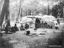
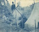
| Date: | 1906 |
|---|---|
| Description: | Ojibwa chief's lodge from Lac Courte Orielles Reservation set up at the 1906 Wisconsin State Fair. Note both reed and bark coverings on the lodge. A number... |
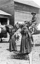
| Date: | 1909 |
|---|---|
| Description: | A group of four Native American children thought to have been photographed at the Menominee Reservation. This image is part of an exhibit about Native Amer... |
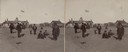
| Date: | |
|---|---|
| Description: | Children outdoors for recess at the Lower Cut Meat Creek School, part of the Rosebud Agency. |
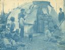
| Date: | |
|---|---|
| Description: | Cyanotype print of Chippewa (Ojibwa) Indians near Bradley Junction which is near Minocqua. The group is standing in front of a wigwam, and a woman in the r... |
| Date: | |
|---|---|
| Description: | Cyanotype print of Chippewa (Ojibwa) Indians near Bradley Junction, near Minocqua. A man wearing a suit and hat is standing in the background. |

| Date: | 1936 |
|---|---|
| Description: | Loading a large white pine log cut on the Menominee Indian Reservation onto a truck. The log was hauled to the Wisconsin State Fair for a display about the... |

| Date: | 1939 |
|---|---|
| Description: | This map shows the towns to Gingles, Sanborn, and Guney as well as Chequamegon Bay, Kakagon River, White River, Marengo River, Bad River, Potato River, Vau... |

| Date: | 1937 |
|---|---|
| Description: | This Wisconsin Conservation Department map shows the locations of state forests, national forests, county forests, state nurseries, Indian reservations, st... |

| Date: | 1902 |
|---|---|
| Description: | This 1902 map of the eastern portion of Sawyer County, Wisconsin, shows the township and range system, sections, roads, farm houses, camps, school houses, ... |

| Date: | 1895 |
|---|---|
| Description: | This late 19th century map of northern Wisconsin and a portion of Michigan's Upper Peninsula shows the township and range grid, the (Lac du) Flambeau India... |

| Date: | 1975 |
|---|---|
| Description: | This map shows boundaries, roads, national forest land, bogs and wetlands, lakes, campgrounds, and boat landings. |

| Date: | 2000 |
|---|---|
| Description: | This map shows national parks, county and state forests, Indian reservations, municipal land, private land, docks, boat access, camping, and points of inte... |

| Date: | 1994 |
|---|---|
| Description: | This map shows historical sites, picnic grounds, public boat landings, canoe and motor boat trips, and resort locations. The left margin of the map include... |

| Date: | 1967 |
|---|---|
| Description: | This colored map published by the State Historical Society of Wisconsin shows key points of interest telling the story of Wisconsin's earliest settlement a... |

| Date: | 1972 |
|---|---|
| Description: | This colored map displays Wisconsin and bordering areas of Iowa, Minnesota, and Michigan. There is color-coding on the map to indicate National Forests, an... |

| Date: | 1971 |
|---|---|
| Description: | This colored map displays Wisconsin and bordering areas of Iowa, Minnesota, and Michigan. There is color-coding on the map to indicate National Forests, an... |

| Date: | 1973 |
|---|---|
| Description: | This colored map displays Wisconsin and bordering areas of Iowa, Minnesota, and Michigan. There is color-coding on the map to indicate National Forests, a... |
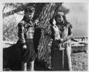
| Date: | 1936 |
|---|---|
| Description: | Walker Reid (1929-2016) standing alongside tree with Indian girl. Reid Walker shown is 7-years-old, and is the son of Carol McMillan Reid. Portrait taken a... |
If you didn't find the material you searched for, our Library Reference Staff can help.
Call our reference desk at 608-264-6535 or email us at: