 Filter: Categories of Wisconsin Historical Images
Filter: Subject of Recreation
Filter: Type of Map or Atlas
Filter: County of Walworth
Filter: Categories of Wisconsin Historical Images
Filter: Subject of Recreation
Filter: Type of Map or Atlas
Filter: County of Walworth

| Date: | 1882 |
|---|---|
| Description: | Bird's-eye map of Lake Geneva, looking southwest, with insets of points of interest. |

| Date: | 1870 |
|---|---|
| Description: | Bird's-eye view of Whitewater, with insets. |

| Date: | 1930 |
|---|---|
| Description: | Shows roads, fire stations, golf course, and accommodations around Delavan Lake. "The drive around the lake is divided into zones from 0 to 900 as shown. P... |

| Date: | 1966 |
|---|---|
| Description: | This 1966 map shows topography, roads, highways, golf courses, government buildings, and businesses around Delavan Lake in Walworth County, Wisconsin. Incl... |

| Date: | 1959 |
|---|---|
| Description: | This map of Lake Geneva has relief shown by contours and water depths shown by isolines. The map includes an index of schools, churches, public services, i... |

| Date: | 1882 |
|---|---|
| Description: | This pictorial bird's-eye-view map shows buildings, streets, and railroads. Included are illustrations and an index to points of interest. The bottom of th... |

| Date: | 1965 |
|---|---|
| Description: | This map shows proposed streets, arterial and collector streets, lot numbers and dimensions, parks, the disposal plant, a ball park, and school property. T... |
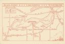
| Date: | 1935 |
|---|---|
| Description: | This map shows Black Point estate including buildings and signs, as well as a school and store near the village of Linton, country clubs, roads, Yerkes Obs... |
If you didn't find the material you searched for, our Library Reference Staff can help.
Call our reference desk at 608-264-6535 or email us at: