 Filter: Categories of Wisconsin Historical Images
Filter: Subject of Real estate development
Filter: Subject of roads
Filter: Categories of Wisconsin Historical Images
Filter: Subject of Real estate development
Filter: Subject of roads

| Date: | 08 28 1970 |
|---|---|
| Description: | An aerial view of West Towne Shopping Center (now West Towne Mall) at Mineral Point and Gammon Roads. |

| Date: | 06 07 1954 |
|---|---|
| Description: | Aerial view of the Midvale neighborhood under construction showing the intersection of Midvale and Tokay Boulevards near the southwestern city limits of Ma... |

| Date: | 06 07 1954 |
|---|---|
| Description: | Aerial view looking north from near the city's southwestern limits in 1954. Shows text indicating Midvale Boulevard, Odana Road, Tokay Boulevard, Mineral P... |

| Date: | 1955 |
|---|---|
| Description: | Aerial view of Midvale neighborhood under construction near Madison's southwestern city limits. The view is focused on the area bounded by Tokay Boulevard,... |

| Date: | 1958 |
|---|---|
| Description: | Aerial view of Craig Avenue and Crestwood Avenue. |
| Date: | 02 26 1930 |
|---|---|
| Description: | Entrance to Westmorland subdivision on Mineral Point Road. |
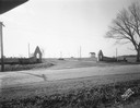
| Date: | 1936 |
|---|---|
| Description: | View down road of mass-produced residential housing with farm in background. |

| Date: | 12 07 1948 |
|---|---|
| Description: | Houses on the south side of the 2100 block of University Avenue. The address on the entrance at the far right is 2125. |
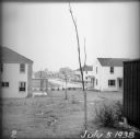
| Date: | 07 05 1938 |
|---|---|
| Description: | A recently planted sapling in the backyard of an empty house, with other houses and roads visible in the background. |
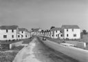
| Date: | 1936 |
|---|---|
| Description: | View from lawn of curved residential street lined with recently constructed housing and lampposts. A car sits in a driveway of a house on the left, and fur... |

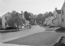
| Date: | 1936 |
|---|---|
| Description: | View up residential street with newly constructed houses, young trees and lampposts. Men in suits and hats walk along the sidewalk. A speed limit sign is o... |

| Date: | 1874 |
|---|---|
| Description: | Map shows townships and sections, landownership and acreages, railroads, and roads. The map was compiled by the civil engineer and city surveyor agent H.I.... |

| Date: | 1939 |
|---|---|
| Description: | This is a zoning map of Wauwatosa with a key of districts including agricultural, resident, business, commercial, and industrial. The map features labeled ... |

| Date: | 1900 |
|---|---|
| Description: | This photostat map was probably originally created in 1835 and shows in addition to private claims, mills, roads, and trails. Green Bay and the Fox River a... |

| Date: | 1880 |
|---|---|
| Description: | This map covers parts of Minnesota, Iowa, and South Dakota and advertised 1,000,000 acres of land available. Communities, roads, and railroad lines are lab... |
| Date: | 1900 |
|---|---|
| Description: | A map of Lake Geneva, including the villages of Williams Bay and Fontana, and a portion of the city of Lake Geneva. The Chicago and Northwestern Railway li... |

| Date: | 1891 |
|---|---|
| Description: | This blueprint manuscript map shows land owned by Green Bay & Mississippi Canal Co., Meade, Vilas, Patten, and Hewitt. Streets and the Fox River are labele... |

| Date: | 1920 |
|---|---|
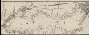
| Description: | This bird's-eye-view map shows plat of area, numbered blocks and lots, local streets, roads, parks, golf club, schools, buildings, landscaping, and part of... |

| Date: | 1915 |
|---|---|
| Description: | This map shows streets and lots with prices available through the Madison Realty Company. Some of the plats include legends. The areas include: Brooks' Add... |
If you didn't find the material you searched for, our Library Reference Staff can help.
Call our reference desk at 608-264-6535 or email us at:
