 Filter: Categories of Wisconsin Historical Images
Filter: Subject of Railroads
Filter: Categories of Wisconsin Historical Images
Filter: Subject of Railroads
| Date: | 1925 |
|---|---|
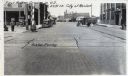
| Description: | View of the railroad crossing where rubber paving was used for the first time in the United States. Caption at top reads: "First Rubber Crossing in U.S. S.... |
| Date: | 1900 |
|---|---|
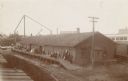
| Description: | View of the Racine and Mississippi freight and passenger depot with multiple individuals lined up on the platform. |

| Date: | 1880 |
|---|---|
| Description: | This map shows railroads by operator and projected railroads. Portions of Lake Michigan, Lake Superior, Illinois, Iowa, Michigan and Minnesota are labeled. |
| Date: | 1886 |
|---|---|
| Description: | View of the Chicago, Burlington, and Quincy railroad drawbridge and trestle. |

| Date: | 1948 |
|---|---|
| Description: | A preliminary sketch for the left panel of the Centennial Mural in the Wisconsin Historical Society. The panel represents Wisconsin's political history. ... |

| Date: | 1896 |
|---|---|
| Description: | Map showing the Wisconsin Central Railroad and its land grant, with the railroad and the land grant in color (red). |

| Date: | 1909 |
|---|---|
| Description: | [Lithography] by Poole Bros. Contains descriptive information. Short jaunts for busy people to nearby resorts in Illinois and Wisconsin. |
| Date: | 1908 |
|---|---|
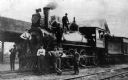
| Description: | Chicago, Milwaukee and St. Paul Railway locomotive no. 186, a class G-5 built by the Baldwin Locomotive Works in 1892, on service on the La Crosse Division... |
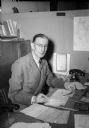
| Date: | 11 04 1944 |
|---|---|
| Description: | Harry G. Marsh, passenger agent for the Chicago & Northwestern Railroad, seated at his desk. Mr. Marsh was responsible for troop movements to and from Trua... |

| Date: | |
|---|---|
| Description: | Plat map of the east central part of the city. |

| Date: | 1882 |
|---|---|
| Description: | This basic reference map of the state shows natural features, railroads, county seats, and political boundaries against the G.L.O. township and range grid.... |

| Date: | 1868 |
|---|---|
| Description: | Showing the counties, towns and railroads. Partly colored. Scale: 1 inch = 20 miles. |

| Date: | 1898 |
|---|---|
| Description: | Shows railway lines in Wisconsin marked in red and counties in colors. The meridians are Greenwich, Wisconsin and Washington, Wisconsin. The map folds into... |

| Date: | 1859 |
|---|---|
| Description: | This 1859 railroad map shows counties, cities, rivers and lakes in the entire state of Wisconsin. It includes an inset depicting the railroads in Milwaukee... |
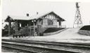
| Date: | 1916 |
|---|---|
| Description: | Chicago, Milwaukee, and St. Paul Railway depot. Side view of depot with windmill in background. |

| Date: | 1916 |
|---|---|
| Description: | Southeastern Wisconsin which lies east of Whitewater and south of Port Washington. |

| Date: | 1913 |
|---|---|
| Description: | Shows lands in green owned and for sale by Homeseekers Land Company, H.J. McKusick, Secretary. Map, part colored. No scale. Photographs on reverse of origi... |

| Date: | 1908 |
|---|---|
| Description: | Colored map in perspective indicates railroad routes. Lake Winnebago and Oshkosh in center, area extends to Shawano (top right corner), Green Bay (bottom r... |
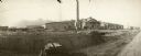
| Date: | |
|---|---|
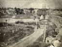
| Description: | Shops under construction for the Chicago, St. Paul, Minneapolis, and Omaha railroad lines. Men are working with a horse-drawn wagon in the right foreground... |

| Date: | |
|---|---|
| Description: | View from hill towards the elevated Chicago, St. Paul, Minneapolis and Omaha railroad bridge over the Chippewa River at Eau Claire. |
If you didn't find the material you searched for, our Library Reference Staff can help.
Call our reference desk at 608-264-6535 or email us at: