 Filter: Categories of Wisconsin Historical Images
Filter: Subject of Railroads
Filter: Year of 1900-1999
Filter: Year of 1950-1959
Filter: Subject of water
Filter: Categories of Wisconsin Historical Images
Filter: Subject of Railroads
Filter: Year of 1900-1999
Filter: Year of 1950-1959
Filter: Subject of water

| Date: | 1950 |
|---|---|
| Description: | An aerial view of town, showing a major industrial area. |

| Date: | 1953 |
|---|---|
| Description: | A map of Lake Mendota that shows depths and the locations of various species of fish in lake. The maps also identifies a number of selected roads and stree... |

| Date: | 1959 |
|---|---|
| Description: | This map identifies public forest land and industrial forest land as of 1959 in Oneida County, Wisconsin, using a 1930 base map showing the township and ra... |

| Date: | 1952 |
|---|---|
| Description: | This map of the northern parts of the Chequamegon Bay area in Bayfield and Ashland counties, Wisconsin, shows trails, roads, railroads, stations, the towns... |

| Date: | 1956 |
|---|---|
| Description: | This 1956 map shows sections, cities and villages, roads, railroads, and lakes and streams in the Eagle River area. All or part of the towns of Plum Lake, ... |

| Date: | 1955 |
|---|---|
| Description: | This 1950s tourist brochure features a map of Burnett County, Wisconsin, and northern Polk County which shows highways and roads, railroads, landmarks, and... |

| Date: | 02 1956 |
|---|---|
| Description: | This 1956 map of Waukesha County, Wisconsin, shows the township and range grid, towns, sections, cities and villages, roads, railroads, dams, airports, par... |

| Date: | 1953 |
|---|---|
| Description: | This mid 20th century map of Vilas County and northeastern Oneida County, Wisconsin, shows the township and range grid, sections, cities and villages, rail... |

| Date: | 1956 |
|---|---|
| Description: | Includes street index. Shows local streets, parks, highways, railroads, Fond du Lac River, and part of lake Winnebago. Also includes text on points of inte... |

| Date: | 1956 |
|---|---|
| Description: | Includes street index and index to points of interest. Shows land ownership by name, plat of town, local streets, schools, parks, highways, railroads, ward... |

| Date: | 1952 |
|---|---|
| Description: | Map shows roads, highways, railroads, parks, city buildings, schools, cemeteries, city limits, and the Fox River. The map is indexed by street name, street... |

| Date: | 1957 |
|---|---|
| Description: | Map is indexed by street name in the margins. The map shows roads, highways, railroads, parks, city buildings, schools, cemeteries, city limits, and the Fo... |

| Date: | 1950 |
|---|---|
| Description: | This map of Sturgeon Bay is part of the survey of the northern and northwestern lakes. The map shows lights, railroads, roads, and some public buildings. R... |

| Date: | 1951 |
|---|---|
| Description: | This map of Superior shows labeled streets, waterways, railroads, and company ownership of docks. |

| Date: | 1954 |
|---|---|
| Description: | This map of Waukesha shows numbered ward boundaries, roads, and some buildings. The bottom of the map includes a street index. |
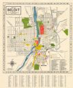
| Date: | 1952 |
|---|---|
| Description: | This colorful map of Beloit shows roads, railroads, rivers, creeks, business districts, industrial areas, and parks and recreation areas. The map includes ... |

| Date: | 1950 |
|---|---|
| Description: | Aerial view showing shipyards, rivers and roads. |

| Date: | 1954 |
|---|---|
| Description: | This map of La Crosse shows residential, multiple dwelling, local business, commercial, light industrial, heavy industrial and special multiple dwelling la... |

| Date: | 1956 |
|---|---|
| Description: | This map is intended for tourists of La Crosse. The front of the map is text about attractions, activities, and accommodations in La Crosse. The back is th... |
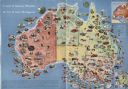
| Date: | 1950 |
|---|---|
| Description: | Color illustrated map of Australia shows various resources available in the different regions of Australia. Original caption: "Australia is the the mi... |
If you didn't find the material you searched for, our Library Reference Staff can help.
Call our reference desk at 608-264-6535 or email us at: