 Filter: Categories of Wisconsin Historical Images
Filter: Subject of Railroads
Filter: Year of 1900-1999
Filter: Year of 1930-1939
Filter: Year of 1936
Filter: Categories of Wisconsin Historical Images
Filter: Subject of Railroads
Filter: Year of 1900-1999
Filter: Year of 1930-1939
Filter: Year of 1936
| Date: | 10 27 1936 |
|---|---|
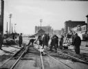
| Description: | Railroad construction crew working on a Chicago & Northwestern Railroad crossing, looking west up the 400 and 500 blocks of East Wilson Street. |
| Date: | 10 27 1936 |
|---|---|
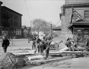
| Description: | Construction crew working on a Chicago & Northwestern Railroad crossing, looking northwest along the 100 block of South Blair Street. |

| Date: | 12 16 1936 |
|---|---|
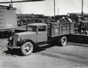
| Description: | A man places a bag onto the bed of an International C-1 truck owned by the Chicago Rock Island Railroad. The truck is marked with the text "No.9" and "Wate... |
| Date: | 1936 |
|---|---|
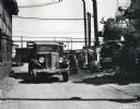
| Description: | An International Model C-35 is parked near a building. To the right men are working on a locomotive for the Missouri Pacific Railroad. The front of another... |
| Date: | 06 02 1936 |
|---|---|
| Description: | Slightly elevated view of men loading the bed of an International Model C-35 truck parked behind a railroad car. The men are standing on a platform at the ... |

| Date: | 1936 |
|---|---|
| Description: | This pictorial tourist map from the Wisconsin Conservation Commission depicts vacation activities and identifies tourist destinations throughout the state.... |

| Date: | 1936 |
|---|---|
| Description: | This map of Neenah and Menasha shows some parks, churches, convention halls, and other buildings. These points of interest are in red ink. Streets, Little ... |

| Date: | 1936 |
|---|---|
| Description: | This colored road map shows automobile roads in Wisconsin as well as portions of Michigan, Iowa, Minnesota, and Illinois. U.S. numbered highways are shown ... |

| Date: | 1936 |
|---|---|
| Description: | This colored road map shows automobile roads in Wisconsin as well as portions of nearby states. U.S. numbered highways are shown in red, and information ab... |

| Date: | 1936 |
|---|---|
| Description: | This colored road map shows automobile roads in Wisconsin as well as portions of nearby states. Information on the quality and type of any given road (pave... |

| Date: | 1936 |
|---|---|
| Description: | This colored road map shows automobile roads in Wisconsin as well as portions of nearby states. Information on the quality and type of any given road (pave... |
If you didn't find the material you searched for, our Library Reference Staff can help.
Call our reference desk at 608-264-6535 or email us at: