 Filter: Categories of Wisconsin Historical Images
Filter: Subject of Railroads
Filter: Year of 1900-1999
Filter: Type of Map or Atlas
Filter: Categories of Wisconsin Historical Images
Filter: Subject of Railroads
Filter: Year of 1900-1999
Filter: Type of Map or Atlas

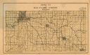
| Date: | 1930 |
|---|---|
| Description: | This road map of Chippewa County, Wisconsin, dates to around 1930. It shows the township and range grid, towns, sections, cities and villages, railroads, l... |

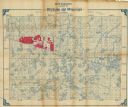
| Date: | 1909 |
|---|---|
| Description: | This 1909 bird's-eye view of Madison and the surrounding Four Lakes region shows roads, railroads, selected buildings in Madison, and points of interest ar... |

| Date: | 1925 |
|---|---|
| Description: | This 1925 map of Dane County, Wisconsin, issued by the Madison Association of Commerce shows the township and range grid, towns, sections, cities and villa... |

| Date: | 1920 |
|---|---|
| Description: | This map of Devil's Lake State Park in Sauk County, Wisconsin, shows the park limits, railroads, roads, creeks, trails, and points of interest in the area.... |

| Date: | 1926 |
|---|---|
| Description: | Map showing Devil's Lake State Park limits, railroads, roads, creeks, trails, and park sites. Accompanying text about the location, natural features, attra... |

| Date: | 1911 |
|---|---|
| Description: | This 1911 map of the geology of northern Wisconsin between Superior and Hurley was published by the Wisconsin Geological and Natural History Survey in Fred... |
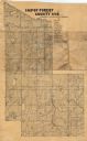
| Date: | 1926 |
|---|---|
| Description: | Map of Eau Claire County, Wisconsin Shows highways, railroads, hydrography, and townships. |

| Date: | 1904 |
|---|---|
| Description: | Map shows townships and sections, landownership and acreages, roads and railroads, and selected buildings. "1904" inscribed on map in pen. Includes busines... |
| Date: | 1908 |
|---|---|
| Description: | Map shows swamps, windfalls, roads and railroads. Status of some land marked (O, S, X) but lacks explanation. |

| Date: | 1903 |
|---|---|
| Description: | Map of Brown County, Wisconsin, shows the township and range grid, towns, sections, cities, villages and post offices, land owners and acreages, railroads,... |

| Date: | 1961 |
|---|---|
| Description: | Map of the Town of Preble, Brown County, Wisconsin, showing land ownership by name, subdivisions, roads and streets, railroads, and local businesses. |

| Date: | 03 1911 |
|---|---|
| Description: | This 1911 topographic map shows Lake Winnebago and the surrounding area. The township and range grid, counties, towns, sections, cities, villages and post ... |

| Date: | 1915 |
|---|---|
| Description: | This 1915 map covers the section of the Wisconsin River in southern Adams, southeastern Juneau, northeastern Sauk, and northwestern Columbia counties. A po... |

| Date: | 1992 |
|---|---|
| Description: | This 1992 map of Wood County, Wisconsin, shows towns, sections, cities and villages, highways and roads, railroads, and lakes and streams. An inset map of ... |

| Date: | 1914 |
|---|---|
| Description: | Shows land ownership by name, rural routes, improved roads, railroads, schools, churches, and cemeteries. "For list of small property owners, lift map at f... |
| Date: | 1902 |
|---|---|
| Description: | Shows swamps, lakeside acreages, railroads, trails, and townships in parts of Vilas and Iron Counties, Wisconsin and Gogebic County, Michigan. Relief shown... |

| Date: | 1907 |
|---|---|
| Description: | Shows post offices, railroads, country clubs, and land ownership by name. Also shows the cities of Lake Geneva and Delavan and Lake Como. "Suggestions for ... |
| Date: | 1927 |
|---|---|
| Description: | Shows landowner's lots, roads, railroads, and Fox River. Also includes certificate of survey text. Includes significant manuscript annotations depicting th... |

| Date: | 1927 |
|---|---|
| Description: | Street railway and motor bus map with a legend of "Street Car Line," "Auxiliary Bus Lines," and "Motor Bus Lines." The routes are numbered. The map reads: ... |

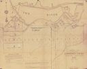
| Date: | 1917 |
|---|---|
| Description: | Shows property already platted (orange), public property (green), street railway (red lines), Lake Forest development area (red), and some landownership. T... |
If you didn't find the material you searched for, our Library Reference Staff can help.
Call our reference desk at 608-264-6535 or email us at: