 Filter: Categories of Wisconsin Historical Images
Filter: Subject of Railroads
Filter: Subject of maps
Filter: Year of 1900-1999
Filter: Categories of Wisconsin Historical Images
Filter: Subject of Railroads
Filter: Subject of maps
Filter: Year of 1900-1999
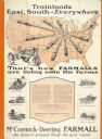
| Date: | 1928 |
|---|---|
| Description: | Advertising poster for McCormick-Deering Farmall tractors showing a map of the United States with trains speeding in all directions from Illinois. Bears th... |
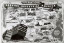
| Date: | 1940 |
|---|---|
| Description: | Map illustrating the industrial uses of International crawler tractors (TracTracTors) across the United States. Includes the text: "International Serving I... |
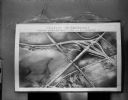
| Date: | 10 11 1950 |
|---|---|
| Description: | Display illustrating the Highway Department's plan for separating highway traffic on Highways 13 and 14 (the Oregon Road) and Highway 12 (the new South Mad... |
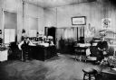
| Date: | 1903 |
|---|---|
| Description: | Superintendent J.N. Harrison and dispatcher W.H. Wright are seated at desks in the Wisconsin & Michigan Railroad office. |
| Date: | 03 26 1944 |
|---|---|
| Description: | Front cover and menu listing from the Villa Ferrovieri in Italy with the Chicago Milwaukee St. Paul & Pacific (CMSP&P) logo printed in red ink on the cover... |

| Date: | 1916 |
|---|---|
| Description: | This map shows railroads, cities, rivers, lakes, and county boundaries. Select railroads are outlined in red. Portions of western Wisconsin Minnesota are v... |

| Date: | 12 1912 |
|---|---|
| Description: | Sanborn map of Sun Prairie, which includes an index and information about water facilities and the fire department. Includes a small inset map of the State... |

| Date: | 1914 |
|---|---|
| Description: | This map shows township grids, railroads, roads, and drainage. The area of the map covers northeastern Wisconsin and Menominee Indian reservation. Green Ba... |

| Date: | 1915 |
|---|---|
| Description: | This map shows roads, railroads, street railways, abandoned logging railroads, rural mail routes, telephone lines, schools, platted land, and state forest ... |

| Date: | 1910 |
|---|---|
| Description: | This map shows the Soo Line railroad and Arpin Hardwood Lumber Company lands in red. The top margin of the map reads: "Wisconsin, the safest state in the U... |

| Date: | 1940 |
|---|---|
| Description: | This blue line print map traced from aerial survey mosaic shows reservation boundary, roads, trails, and railroads. Color manuscript annotations show triba... |

| Date: | 1911 |
|---|---|
| Description: | This map shows streets, railroads, the city house numbering system, and the Rock River. The left margin includes a street index. |

| Date: | 1920 |
|---|---|
| Description: | This map shows the entire state as well as portions of Iowa, Illinois, Minnesota, and Michigan. Counties outlined in yellow, cities, rivers, lakes, and rai... |

| Date: | 1966 |
|---|---|
| Description: | This blue line print shows existing and proposed streets, docks, company-owned land, railroads and railroad yards, parks, and municipal airport. |

| Date: | 1937 |
|---|---|
| Description: | Map showing territory controlled by the Finches, a family of bandits who terrorized south central Wisconsin in the years prior to the Civil War. The map in... |
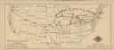
| Date: | 1924 |
|---|---|
| Description: | Map of the United States with tour route taken by the Chicago Civic Opera Company indicated in red. The company traveled on the Baltimore & Ohio Railroad S... |

| Date: | 11 03 1903 |
|---|---|
| Description: | A drawing of a group of burial mounds in Linden Valley. Text on back reads: "These mounds lie at the narrow mouth of Linden Valley on the east side of the ... |
If you didn't find the material you searched for, our Library Reference Staff can help.
Call our reference desk at 608-264-6535 or email us at: