 Filter: Categories of Wisconsin Historical Images
Filter: Subject of Railroads
Filter: Subject of intellectual life
Filter: County of Dane
Filter: Categories of Wisconsin Historical Images
Filter: Subject of Railroads
Filter: Subject of intellectual life
Filter: County of Dane

| Date: | 1908 |
|---|---|
| Description: | Colored map showing a panoramic view of Madison in great detail. The Wisconsin State Capitol is located at the center, with Lake Mendota in the background ... |
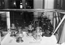
| Date: | 05 15 1943 |
|---|---|
| Description: | Wisconsin Historical Society museum display of railroad lanterns in the "Building Wisconsin Railroads" exhibit. |

| Date: | 1876 |
|---|---|
| Description: | Bird's-eye view of Middleton with an inset of a school house. |

| Date: | 07 17 1857 |
|---|---|
| Description: | A stock certificate of the Watertown and Madison Railroad Company, one share #85, issued to Darwin Clark for the sum of $50.00. This was signed by the rail... |

| Date: | 1885 |
|---|---|
| Description: | Bird's-eye map of Madison, State Capital of Wisconsin, County Seat of Dane County, with inset of the Wisconsin State Capitol. |

| Date: | 1875 |
|---|---|
| Description: | Bird's-eye map of Mazomanie. |

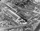
| Date: | 1942 |
|---|---|
| Description: | Aerial view of Oscar Mayer & Company, 910 Mayer Avenue at Packers Avenue. Shows stock yards, railroad cars and automobile parking lot. Also shows C.E. & P.... |
| Date: | 10 18 1945 |
|---|---|
| Description: | Madison Ray-O-Vac plant, 2313-25 Winnebago Street. |
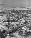
| Date: | 01 22 1949 |
|---|---|
| Description: | Aerial view of the town and the Chicago, Milwaukee, St. Paul and Pacific railroad bridge. |

| Date: | 02 09 1949 |
|---|---|
| Description: | Aerial view of Madison, looking east across the Isthmus including the Wisconsin State Capitol, Lake Mendota, and Lake Monona. |

| Date: | 02 25 1949 |
|---|---|
| Description: | One of six aerial images of Mount Horeb. |
| Date: | 03 22 1950 |
|---|---|
| Description: | Walter S. Alcumbrac, Madison superintendent of the Madison division of the Chicago and North Western Railway Company, (right) receives a plaque for the bes... |
| Date: | 10 11 1950 |
|---|---|
| Description: | Display illustrating the Highway Department's plan for separating highway traffic on Highways 13 and 14 (the Oregon Road) and Highway 12 (the new South Mad... |
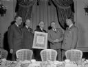
| Date: | 03 19 1952 |
|---|---|
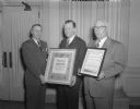
| Description: | Three men are shown with two awards commemorating North Western railroad safety. P.E. Feucht, executive vice-president (center), presented the Madison divi... |

| Date: | 02 17 1913 |
|---|---|
| Description: | Cyanotype menu for a Railroad Commission Dinner Dance, with a train steaming down the tracks, the seal of the state of Wisconsin, and two presentations of ... |

| Date: | 12 1912 |
|---|---|
| Description: | Sanborn map of Sun Prairie, which includes an index and information about water facilities and the fire department. Includes a small inset map of the State... |

| Date: | |
|---|---|
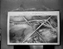
| Description: | Aerial view over Monona Bay showing two railroads crossing in the center. Olin Park is on the top left. |

| Date: | 06 1960 |
|---|---|
| Description: | Aerial view looking northwest showing an area to be redeveloped into high-rise dormitories. Lake Mendota and Bascom Woods can be seen at the top. Universit... |

| Date: | 1967 |
|---|---|
| Description: | Air view looking north toward Lake Mendota. The intersection of West Washington Ave. and S. Park Street is at bottom center. The Triangle Redevelopment Pro... |
If you didn't find the material you searched for, our Library Reference Staff can help.
Call our reference desk at 608-264-6535 or email us at:
