 Filter: Categories of Wisconsin Historical Images
Filter: Subject of Railroads
Filter: Subject of breweries
Filter: Categories of Wisconsin Historical Images
Filter: Subject of Railroads
Filter: Subject of breweries

| Date: | 1882 |
|---|---|
| Description: | This map of Cedarburg is a bird's-eye map with an inset of Cedarburg Brewery. Relief is shown pictorially and the map includes an index to buildings. |

| Date: | 2007 |
|---|---|
| Description: | This map of Cedarbug is a bird's-eye map with 8 inset views and an index. The map is a print out of the original map dated 1892 held at the Cedarburg Cultu... |

| Date: | 1878 |
|---|---|
| Description: | Bird's-eye map of Chilton with insets of points of interest, including P.H. Becker's Brewery, Chilton House, and Gutheil's Block. |

| Date: | 1871 |
|---|---|
| Description: | Birds eye map of Monroe, WI, depicts street names and street locations, houses, and trees. A reference key at the bottom of the map shows the locations of ... |

| Date: | 1911 |
|---|---|
| Description: | Elevated view of the John Gund Brewing Company buildings, with the Mississippi River in the background. Caption reads: "John Gund Brewing Co., La Crosse, W... |

| Date: | 1860 |
|---|---|
| Description: | Image drawn by Franz Hölzlhuber of early Milwaukee settlement with a horse-drawn carriage, as well as industry and a railroad. The text on the image reads:... |

| Date: | |
|---|---|
| Description: | Elevated view of Dawson and Klondike City, looking north. Klondike Brewery is labeled in the foreground at left. Published by Landahl's Emporium. |

| Date: | |
|---|---|
| Description: | Letterhead of the Chilton Branch of the Falk Jung & Borchert Brewing Company, headquartered in Milwaukee, Wisconsin. It includes, on the left, an elevated ... |

| Date: | |
|---|---|
| Description: | Letterhead of the John Gund Brewing Company of La Crosse, Wisconsin, with an elevated view of the brewery complex on the left. On the right is the company ... |

| Date: | |
|---|---|
| Description: | Memohead of the Joseph Schlitz Brewing Company of Milwaukee, Wisconsin, with an elevated view of the brewery complex, including an elevator and other stora... |

| Date: | |
|---|---|
| Description: | Letterhead of the Phillip Best Brewing Company of Milwaukee, Wisconsin, with three separate proscenium views of the Empire Brewery, the South Side Brewery,... |
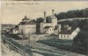
| Date: | 1910 |
|---|---|
| Description: | Postcard of the Stork Brewery facilities. The image includes the brewery buildings along a hillside and railroad tracks in the foreground. There is a sign ... |

| Date: | |
|---|---|
| Description: | Colorized postcard view of the Storck Brewery in Schleisingerville (now Slinger). The brewery buildings are along a hillside, and railroad tracks are in th... |

| Date: | 09 1884 |
|---|---|
| Description: | Sanborn map of Fort Atkinson including Barrie, Germany, and North Water Streets. |

| Date: | 1947 |
|---|---|
| Description: | A map of Manitowoc County that shows the location and dates of seven pig fairs in the county; it also lists monthly pig and cattle sales in the surrounding... |

| Date: | 1870 |
|---|---|
| Description: | This 1870 map of Brown County, Wisconsin, shows the township and range grid, towns, sections, cities, villages and post offices, land ownership, roads, rai... |

| Date: | 1859 |
|---|---|
| Description: | This map show plats including plat names, plat numbers, and some lot owner's names. Relief is shown by hachures. The map includes line drawings of Juneau B... |

| Date: | 1886 |
|---|---|
| Description: | This map has relief shown by hachures and includes a list of plats in order of date of record, laws which vacate plats, plats not shown as upon the county ... |

| Date: | 1883 |
|---|---|
| Description: | This map shows ward boundaries, names of additions, streets, bridges, mills, schools, religious buildings, businesses, hotels, railroads, factories, brewer... |
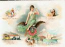
| Date: | 1895 |
|---|---|
| Description: | Composite art page from a booklet of verses about Miller Beer. Images include a woman at top left who is perhaps working with hops, captioned: "Original Mi... |
If you didn't find the material you searched for, our Library Reference Staff can help.
Call our reference desk at 608-264-6535 or email us at: