Filter: Categories of Wisconsin Historical Images
Filter: Subject of Railroads
Filter: Subject of boats and boating
Filter: Categories of Wisconsin Historical Images
Filter: Subject of Railroads
Filter: Subject of boats and boating
| Date: | |
|---|---|
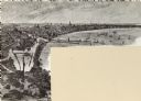
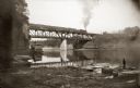
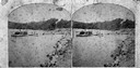
| Description: | Chicago, Milwaukee and St. Paul passenger train on Kilbourn railroad bridge. "Apollo No. 1" steamboat below bridge, with musicians in bow. Various launch b... |
| Date: | |
|---|---|
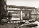
| Description: | View of Kilbourn bridge with railroad train. Steamboat and rowboats at edge of river. |
| Date: | |
|---|---|
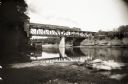
| Description: | Bridge over river with railroad train. "Apollo No. 1" steamboat under bridge. Boats are along the shoreline. |

| Date: | 1868 |
|---|---|
| Description: | This 1868 birds-eye view depicts the buildings, streets, railroad, vegetation and topography of Columbus, Wisconsin. The high school, cemetery, railroad de... |

| Date: | 1885 |
|---|---|
| Description: | Bird's-eye map of Oconomowoc. |

| Date: | 1874 |
|---|---|
| Description: | Bird's-eye map of Chippewa Falls. |

| Date: | 1877 |
|---|---|
| Description: | Bird's-eye map of Janesville on the Rock River. |

| Date: | 1927 |
|---|---|
| Description: | Color map, hand-drawn with comic figures engaged in various activities throughout map. Bordered by the river on the left and Lake Michigan on the right, in... |

| Date: | 1870 |
|---|---|
| Description: | Birds-eye drawing of Oconomowoc depicts street names and street layouts, houses, trees, Oconomowoc River, Fowler Lake, and La Belle Lake. A reference key a... |

| Date: | 1883 |
|---|---|
| Description: | Bird's-eye map of Prairie du Sac, Wisconsin with an inset of Clifton. |

| Date: | 1879 |
|---|---|
| Description: | Bird's-eye map of Two Rivers. |

| Date: | 1874 |
|---|---|
| Description: | Bird's-eye view of Waukesha, looking southwest, with insets of State Industrial School, Court House, and Fountain Spring House. |

| Date: | 1870 |
|---|---|
| Description: | Bird's-eye view of Whitewater, with insets. |
| Date: | 1874 |
|---|---|
| Description: | View west from the Cliff House at Devil's Lake. |
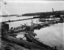
| Date: | 10 07 1911 |
|---|---|
| Description: | Elevated view of the rising waters of the Wisconsin River at the construction site. This view shows the coffer dam, pile drivers, and narrow gauge railroad... |
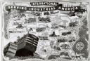
| Date: | 1940 |
|---|---|
| Description: | Map illustrating the industrial uses of International crawler tractors (TracTracTors) across the United States. Includes the text: "International Serving I... |

| Date: | |
|---|---|
| Description: | Commemorative Civil War roster of First Regiment Wisconsin Volunteer Cavalry, Wisconsin Hussars Squadron "G." Depicts "Our Country as it was in 1860" with ... |
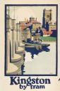
| Date: | 1925 |
|---|---|
| Description: | An original colored lithograph advertising the London Transport system, and promoting travel to "Kingston by Tram." The poster features the artist Frank N... |
If you didn't find the material you searched for, our Library Reference Staff can help.
Call our reference desk at 608-264-6535 or email us at: