 Filter: Categories of Wisconsin Historical Images
Filter: Subject of Railroads
Filter: County of Waukesha
Filter: Categories of Wisconsin Historical Images
Filter: Subject of Railroads
Filter: County of Waukesha

| Date: | 1911 |
|---|---|
| Description: | This 1911 map from the U.S. Post Office Dept. shows rural delivery routes, active and discontinued post offices, selected rural landowners and houses, chur... |

| Date: | 1898 |
|---|---|
| Description: | Map showing the contour depths of the lakes in northwestern Waukesha County, Wisconsin. Roads, railroads, depots, churches, schools, and hotels in the area... |

| Date: | 1873 |
|---|---|
| Description: | Plat map of the township of Eagle (T5N, R17E) at a scale of 2 inches to one mile. |

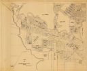
| Date: | 1954 |
|---|---|
| Description: | This map of Waukesha shows numbered ward boundaries, roads, and some buildings. The bottom of the map includes a street index. |
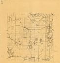
| Date: | 1925 |
|---|---|
| Description: | This map shows township sections, roads, railroads, and lakes. The map also features extensive manuscript annotations noting landownership in pencil. Stamp... |
| Date: | |
|---|---|
| Description: | This map is a photocopy and shows the Oconomowoc River, Flower Lake, lot and block numbers and dimensions, additions, streets, C.M.St.P.&P. Ry., T.M.E.R.&L... |

| Date: | 1980 |
|---|---|
| Description: | This map shows schools, hotels, stations, roads, railroads, reefs, and public buildings. The upper right corner includes "A Summer and Winter Guide for Spo... |

| Date: | 05 24 1952 |
|---|---|
| Description: | The Wisconsin School for Boys Band, under the direction of Arnold Krueger, provided the musical entertainment for the dedication ceremony of the Waukesha D... |
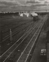
| Date: | 1950 |
|---|---|
| Description: | Elevated view of parallel tracks in a railroad yard, with a locomotive pulling a boxcar. A man is standing near the boxcar. On the right are buildings, and... |

| Date: | 1948 |
|---|---|
| Description: | Aerial view of Waukesha Works, a foundry. |
If you didn't find the material you searched for, our Library Reference Staff can help.
Call our reference desk at 608-264-6535 or email us at:

