 Filter: Categories of Wisconsin Historical Images
Filter: Subject of Railroads
Filter: Creator Name of Unknown
Filter: Categories of Wisconsin Historical Images
Filter: Subject of Railroads
Filter: Creator Name of Unknown

| Date: | 1860 |
|---|---|
| Description: | This map shows roads, trails, and railroads throughout Nebraska, Arkansas, Missouri, Kansas, Illinois, and Utah, including the Salt Lake City & California ... |

| Date: | 1903 |
|---|---|
| Description: | This map shows lakes, roads, railroads, townships, and land ownership by name. Counties are colored red, blue, or yellow. Lake Michigan is labeled. Also in... |

| Date: | 1872 |
|---|---|
| Description: | This map shows wards, roads, railroads, lot and block numbers, subdivisions, parks, some landownership, and a race course. Manuscript annotations in red in... |

| Date: | 1910 |
|---|---|
| Description: | This map shows the locations of school houses, farms, roads, railroads, and Bad River Indian Reservation. Relief is shown by hachures. Yellow and red manus... |

| Date: | 1933 |
|---|---|
| Description: | This blueprint map shows lakes, roads, railroads, townships and sections. A legend is also included that shows highway surface types. |

| Date: | 1920 |
|---|---|
| Description: | This blueprint map covers the boundary area between Lake Superior and the Lac Vieux Desert. The map reads: "Land lines, streams, lakes, railroads, cities a... |
| Date: | 1908 |
|---|---|
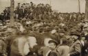
| Description: | Elevated view of a crowd waiting for the "Red Special," Socialist special train. Eugene V. Debs and others were speakers. |

| Date: | 1952 |
|---|---|
| Description: | This map shows roads, foot and canoe trails, railroads, resorts, lookout towers, camps, national and state forests, Indian reservation, and types of fish i... |

| Date: | 1880 |
|---|---|
| Description: | This blueprint map shows proposed railroad tracks between Carroll Street and Wisconsin Avenue along Lake Monona. |

| Date: | 1870 |
|---|---|
| Description: | This blueprint map shows lot and block numbers, streets, and right of way for the Two Rivers Branch railroad. The map covers land west to sections 22 and 2... |

| Date: | 1907 |
|---|---|
| Description: | This manuscript blueprint map shows land parcels pertaining to University Heights region in Madison, Wisconsin. Streets labeled included, University Avenue... |
| Date: | 11 23 1930 |
|---|---|
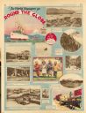
| Description: | Full page illustrated article in the Milwaukee Journal titled "The World Voyagers go Round The Globe by Radio and Roto." Included are photographs an... |

| Date: | 1857 |
|---|---|
| Description: | This map shows lot and block numbers, streets, railroad depots, locks, bridges, dams, canals, U.S. light house, college grounds, a steam boat landing, and ... |

| Date: | 1960 |
|---|---|
| Description: | This dot density map shows the number of shipments in 1952 throughout Wisconsin and to other United States destinations from Neillsville. Mellen, Cable, Bl... |

| Date: | 1960 |
|---|---|
| Description: | This dot density map shows tickets sold in 1913, by destination, from Birchwood, Wisconsin. Several communities are labeled. The bottom right corner has a ... |

| Date: | 1861 |
|---|---|
| Description: | This map shows railroad and other transportation routes in Wisconsin, northern Illinois, the Upper Peninsula of Michigan, portions of Iowa, Minnesota, and ... |

| Date: | 1900 |
|---|---|
| Description: | This map shows logging roads, railroads with spur lines, trails, rapids, lumber camps, Indian villages, summer resort, lakes, rivers, and ponds. |
| Date: | 1878 |
|---|---|
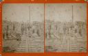
| Description: | Stereograph of a bearded man with vest and suit posing on a narrow gauge railroad at the granite works in Montello. Workmen are posing around him. Most of ... |

| Date: | 1903 |
|---|---|
| Description: | This blue line print shows quartzite areas, mines, railroads, and roads. The map covers townships 11-13 north, ranges 4-8 east, in parts of Sauk and Columb... |

| Date: | 1910 |
|---|---|
| Description: | This map shows the Soo Line railroad and Arpin Hardwood Lumber Company lands in red. The top margin of the map reads: "Wisconsin, the safest state in the U... |
If you didn't find the material you searched for, our Library Reference Staff can help.
Call our reference desk at 608-264-6535 or email us at: