Filter: Categories of Wisconsin Historical Images
Filter: Subject of Railroads
Filter: Creator Name of Unknown
Filter: Year of 1900-1999
Filter: Categories of Wisconsin Historical Images
Filter: Subject of Railroads
Filter: Creator Name of Unknown
Filter: Year of 1900-1999

| Date: | 1960 |
|---|---|
| Description: | This dot density map shows the number of shipments in 1952 throughout Wisconsin and to other United States destinations from Neillsville. Mellen, Cable, Bl... |

| Date: | 1960 |
|---|---|
| Description: | This dot density map shows tickets sold in 1913, by destination, from Birchwood, Wisconsin. Several communities are labeled. The bottom right corner has a ... |

| Date: | 1900 |
|---|---|
| Description: | This map shows logging roads, railroads with spur lines, trails, rapids, lumber camps, Indian villages, summer resort, lakes, rivers, and ponds. |

| Date: | 1903 |
|---|---|
| Description: | This blue line print shows quartzite areas, mines, railroads, and roads. The map covers townships 11-13 north, ranges 4-8 east, in parts of Sauk and Columb... |

| Date: | 1910 |
|---|---|
| Description: | This map shows the Soo Line railroad and Arpin Hardwood Lumber Company lands in red. The top margin of the map reads: "Wisconsin, the safest state in the U... |

| Date: | 1955 |
|---|---|
| Description: | This map shows roads, golf courses, airports, fire towers, schools, camp grounds, rivers, streams, lakes, and railroads. The right margin of the map includ... |

| Date: | 1966 |
|---|---|
| Description: | This blue line print shows existing and proposed streets, docks, company-owned land, railroads and railroad yards, parks, and municipal airport. |

| Date: | 1937 |
|---|---|
| Description: | Map showing territory controlled by the Finches, a family of bandits who terrorized south central Wisconsin in the years prior to the Civil War. The map in... |

| Date: | 1900 |
|---|---|
| Description: | A hand-drawn map of the battlefield of the Battle of Chickamauga. |

| Date: | 1912 |
|---|---|
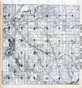
| Description: | A plat map of the township of West Kewaunee. |

| Date: | 1901 |
|---|---|
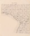
| Description: | A plat map of Marathon county, 28 township, north range, 7 east. |

| Date: | 1901 |
|---|---|
| Description: | A plat map of Marathon county, township 28, north range, 8 east. |

| Date: | 1901 |
|---|---|
| Description: | A plat map of Marathon county, township 29, north range, 6 east. |

| Date: | 1901 |
|---|---|
| Description: | A plat map of Marathon county, township 29, north range, 7 east. |

| Date: | 1901 |
|---|---|
| Description: | A plat map of Marathon county, township 29, north range, 8 east. |

| Date: | 1906 |
|---|---|
| Description: | A diagram of Township No 37 Range No 8 in Sawyer County. |

| Date: | 04 15 1916 |
|---|---|
| Description: | Text on front reads: "Depot and Elevator, St. Cloud, Wis." A view up the railroad tracks with the station on the left and grain elevator on the right, with... |
If you didn't find the material you searched for, our Library Reference Staff can help.
Call our reference desk at 608-264-6535 or email us at: