 Filter: Categories of Wisconsin Historical Images
Filter: Subject of Railroads
Filter: Creator Name of Unknown
Filter: Year of 1800-1899
Filter: County of Dane
Filter: Categories of Wisconsin Historical Images
Filter: Subject of Railroads
Filter: Creator Name of Unknown
Filter: Year of 1800-1899
Filter: County of Dane
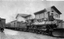
| Date: | 1895 |
|---|---|
| Description: | Chicago, Milwaukee, and St. Paul Railroad train at the old station, 640 West Washington Ave., with snowplow at the old depot. Engineer James F. Mills is i... |

| Date: | 1890 |
|---|---|
| Description: | People and carriages in front of the depot-hotel Railway Hotel on West Washington Avenue. This was the Chicago, Milwaukee, and St. Paul Railway Ticket Offi... |

| Date: | 1876 |
|---|---|
| Description: | Bird's-eye view of Middleton with an inset of a school house. |

| Date: | 07 17 1857 |
|---|---|
| Description: | A stock certificate of the Watertown and Madison Railroad Company, one share #85, issued to Darwin Clark for the sum of $50.00. This was signed by the rail... |

| Date: | 1892 |
|---|---|
| Description: | Topographical map of Madison and surrounding communities which include Lake Mendota, Lake Monona, Lake Waubesa and Lake Kegonsa. The red dots on the map sh... |

| Date: | 1892 |
|---|---|
| Description: | This map oriented with north to the upper left shows railroads, creeks, post offices, smaller lakes, Lake Mendota, Lake Monona, Lake Wingra, Lake Waubesa, ... |

| Date: | 1854 |
|---|---|
| Description: | This mid-19th century map of Dane County, Wisconsin, shows the township and range grid, towns, sections, cities, villages and post offices, lakes and strea... |

| Date: | 1890 |
|---|---|
| Description: | Shows towns of Dane County, lakes, rivers, and railroads. Relief shown by hachures. Includes color illustration of Madison and text describing Dane County ... |

| Date: | 1899 |
|---|---|
| Description: | These two maps of Madison and the Four Lakes region show the site of the Teachers Country Club on Lake Monona, the lakes and the Catfish or Yahara River, f... |

| Date: | 1890 |
|---|---|
| Description: | This late-19th century map of Dane County, Wisconsin, shows the township and range grid, towns, sections, cities and villages, lakes and streams, roads, an... |

| Date: | 1854 |
|---|---|
| Description: | Shows street grid, sections in adjacent townships, routes of railroads and projected railroads, post offices, and creeks. Table of references identifies ma... |

| Date: | 1898 |
|---|---|
| Description: | Shows landownership, buildings, and railroads. Lake Mendota and Lake Wingra are labelled. |

| Date: | 1856 |
|---|---|
| Description: | This map is pen-and-ink on tracing cloth and shows lot numbers and dimensions, lots belonging to H. Wright (shown in red ink), selected buildings, and the ... |

| Date: | 1899 |
|---|---|
| Description: | A plat map showing Lake Monona, the isthmus in Madison, and the towns of Burke and Blooming Grove. |

| Date: | 1880 |
|---|---|
| Description: | This blueprint map shows proposed railroad tracks between Carroll Street and Wisconsin Avenue along Lake Monona. |

| Date: | 1890 |
|---|---|
| Description: | Plat map of Madison, T7N R9E, including portions of the towns of Blooming Grove and Burke. Includes inset maps of South Madison, Quarrytown, Marril Park, a... |
If you didn't find the material you searched for, our Library Reference Staff can help.
Call our reference desk at 608-264-6535 or email us at:

