 Filter: Categories of Wisconsin Historical Images
Filter: Subject of Railroads
Filter: Creator Name of Unknown
Filter: Subject of land
Filter: Categories of Wisconsin Historical Images
Filter: Subject of Railroads
Filter: Creator Name of Unknown
Filter: Subject of land

| Date: | 1838 |
|---|---|
| Description: | A color map of the settled part of Wisconsin Territory in 1838, including an inset map of the "Entire Territory of Wisconsin as Established by Act of Congr... |

| Date: | 1911 |
|---|---|
| Description: | A plat map of the township of Westport in Dane County. |
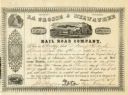
| Date: | 1857 |
|---|---|
| Description: | Engraved document certifying that D. Henry Rockwell of Oconomowoc is entitled to one share of the La Crosse and Milwaukee Rail Road Company worth one hundr... |

| Date: | 1899 |
|---|---|
| Description: | This map is a folded insert from the pamphlet "Yesterday and Today : A History." The map features the North-Western Line with labeled railway tracks and st... |
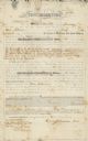
| Date: | 01 29 1853 |
|---|---|
| Description: | Document of agreement between Oren Johnson of Dodge County and the La Crosse and Milwaukee Rail Road Company. Johnson agreed to pay $600 plus 8% annual int... |
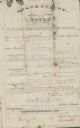
| Date: | 07 09 1853 |
|---|---|
| Description: | Legal title to Oren Johnson's mortgaged land in Dodge County. The La Crosse and Milwaukee Rail Road Company assessed the land for $1,500. |

| Date: | 1951 |
|---|---|
| Description: | This street map shows public buildings and streets. The lower left corner includes a table of street names and the middle right includes text on the street... |

| Date: | 1856 |
|---|---|
| Description: | This map is pen-and-ink on tracing cloth and shows lot numbers and dimensions, lots belonging to H. Wright (shown in red ink), selected buildings, and the ... |

| Date: | 1920 |
|---|---|
| Description: | This blue print map and blue line print copy mounted on cloth shows land ownership by name, campus buildings, local streets, railroads, and part of Lake Me... |

| Date: | 1930 |
|---|---|
| Description: | This map shows city wards, streets, railroads, parks, Lake Butte Des Morts, Lake Winnebago, advertisements for Dixie Oils Gasoline, a list of Cook & Brown ... |

| Date: | 1900 |
|---|---|
| Description: | This map shows streets, railroads, dock and harbor lines, and parks. The map includes population tables for 1880, 1890, 1900. |

| Date: | 1904 |
|---|---|
| Description: | This map is mounted on cloth and shows streets, railways, and city wards. A stamp in the right margin reads: "The Library of Congress, one copy received Fe... |

| Date: | 1856 |
|---|---|
| Description: | This map is ink and color on paper and mounted on cloth. The map shows lot and block numbers, streets, a railroad, and the Kickapoo River. Some lots are c... |

| Date: | 1890 |
|---|---|
| Description: | This map shows lot and block numbers and dimensions, landownership, city wards, buildings, streets, railroads, parks, cemeteries, churches, schools, and in... |

| Date: | 1899 |
|---|---|
| Description: | A plat map showing Lake Monona, the isthmus in Madison, and the towns of Burke and Blooming Grove. |

| Date: | 1960 |
|---|---|
| Description: | This map includes a sheet index showing streets, proposed streets, the high school, and railroad. |

| Date: | 1924 |
|---|---|
| Description: | This map shows streets, selected buildings, railroads, railway yards, schools, parks, schools, cemeteries, bays, the Milwaukee River, and Lake Michigan. De... |

| Date: | 1915 |
|---|---|
| Description: | This map shows school houses, churches, farms, and railroads. Chequamecon Bay and Bad River Indian Reservation are labeld. The map reads: "All lands shown ... |

| Date: | 07 01 1876 |
|---|---|
| Description: | This map shows towns, railroads, and rivers in Ohio, Michigan, Pennsylvania, New York, and Ontario that surround Lake Erie. A key to completed and uncomple... |

| Date: | 1905 |
|---|---|
| Description: | This map shows railroads, towns, lights, lights to be established, fog signals, light-vessels, lighted buoys, light-house depots, and light-house reservati... |
If you didn't find the material you searched for, our Library Reference Staff can help.
Call our reference desk at 608-264-6535 or email us at: