 Filter: Categories of Wisconsin Historical Images
Filter: Subject of Railroads
Filter: Creator Name of Unknown
Filter: Subject of bridges
Filter: Categories of Wisconsin Historical Images
Filter: Subject of Railroads
Filter: Creator Name of Unknown
Filter: Subject of bridges
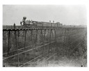
| Date: | 1890 |
|---|---|
| Description: | Wisconsin Central Railroad train on White River Bridge, with crew posing on top of cars. The bridge was 1600 feet long and 110 feet above the water. In 187... |

| Date: | 1874 |
|---|---|
| Description: | Bird's-eye map of Chippewa Falls. |

| Date: | 1874 |
|---|---|
| Description: | Bird's-eye map of Lodi, with inset of Public School. Includes index of churches and points of interest. |

| Date: | 1879 |
|---|---|
| Description: | This map is a bird's-eye view of Wausau, the County Seat of Marathon County. The map features an index of points of interest. |

| Date: | 1930 |
|---|---|
| Description: | Aerial view of the city and the river. |
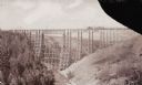
| Date: | |
|---|---|
| Description: | Two Medicine Bridge, part of the Gulf and Northern Railroad. |

| Date: | 1915 |
|---|---|
| Description: | Elevated view of the St. Croix River, Northwest Railroad, bridge, and part of the town of Hudson. Caption reads: "Hudson, Wis. Bird's Eye View, showing St.... |

| Date: | 1940 |
|---|---|
| Description: | Aerial view of the bridge spanning the Mississippi River in La Crosse. |
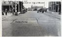
| Date: | 1925 |
|---|---|
| Description: | View of the railroad crossing where rubber paving was used for the first time in the United States. Caption at top reads: "First Rubber Crossing in U.S. S.... |

| Date: | |
|---|---|
| Description: | Plat map of the east central part of the city. |

| Date: | 1915 |
|---|---|
| Description: | Advertisement reads: "Castle-Pierce Printing Company" and "Feb. 1915". Text on right reads: "The Heart of Oshkosh. This birds-eye view represents about one... |

| Date: | 1878 |
|---|---|
| Description: | View from riverbank of the Chicago Milwaukee and St. Paul railroad locomotive no. 142 on the Kilbourn bridge. |
| Date: | |
|---|---|
| Description: | Elevated view of the Washington Bridge, crossing over numerous railroad tracks. In the foreground is a train engine, dwellings, and a dilapidated brick str... |

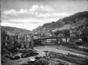
| Date: | |
|---|---|
| Description: | Elevated view of the city, which includes a factory, numerous buildings, railroad tracks, a bridge, Elizabeth river, and hills in the background. |

| Date: | |
|---|---|
| Description: | Elevated view of a small settlement between two mountains and alongside a river with tracks of the first transcontinental railroad passing through. A bridg... |

| Date: | |
|---|---|
| Description: | A railroad bridge crosses over Red Cedar River. |

| Date: | 1902 |
|---|---|
| Description: | Two panoramic bird's-eye views of the Paine Lumber Company, including the general plant, sawmill, and lumber yards. Heading at the top says: Home of Wiscon... |

| Date: | 1908 |
|---|---|
| Description: | This early 20th century map shows the township and range system, sections, state-owned land, selected buildings and landownership, railroads, bridges, and ... |

| Date: | 1908 |
|---|---|
| Description: | This 1908 map shows the township and range grid, sections, towns, villages, railroads, bridges, lakes, streams, rapids, and state-owned lands in Oneida Cou... |

| Date: | 1897 |
|---|---|
| Description: | This 1897 map of Sawyer County, Wisconsin, shows the township and range system, sections, roads, farm houses, camps, school houses, dams, bridges, Indian r... |
If you didn't find the material you searched for, our Library Reference Staff can help.
Call our reference desk at 608-264-6535 or email us at: