 Filter: Categories of Wisconsin Historical Images
Filter: Subject of Railroad bridges
Filter: Year of 1800-1899
Filter: Subject of bridges
Filter: Categories of Wisconsin Historical Images
Filter: Subject of Railroad bridges
Filter: Year of 1800-1899
Filter: Subject of bridges
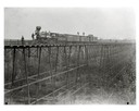
| Date: | 1890 |
|---|---|
| Description: | Wisconsin Central Railroad train on White River Bridge, with crew posing on top of cars. The bridge was 1600 feet long and 110 feet above the water. In 187... |

| Date: | 1896 |
|---|---|
| Description: | Bird's-eye map of Darlington. Area bordered by Washington and North Streets, upper left hand corner, the fairgrounds, upper right corner, River Street, bot... |

| Date: | 1877 |
|---|---|
| Description: | Bird's-eye map of Janesville on the Rock River. |

| Date: | 1893 |
|---|---|
| Description: | Bird's-eye map of Jefferson, looking north. Crayfish River at left and center, Rock River from upper center to bottom center, joins at left of center; thir... |

| Date: | 1870 |
|---|---|
| Description: | Bird's-eye view of the city of Manitowoc with a population of 5,168 inhabitants as it appears in 1870, the year the village was granted a city charter by t... |

| Date: | 1883 |
|---|---|
| Description: | Bird's-eye map of Prairie du Sac, Wisconsin with an inset of Clifton. |

| Date: | 1883 |
|---|---|
| Description: | Bird's-eye map of Sauk City. |

| Date: | 1891 |
|---|---|
| Description: | Bird's-eye map of Stevens Point, looking east, with an inset of the Water Works. Wisconsin River in foreground with fifty-three business locations identifi... |

| Date: | 1879 |
|---|---|
| Description: | Bird's-eye map of Two Rivers. |
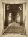
| Date: | 1877 |
|---|---|
| Description: | View of the lower level of the Chicago, Milwaukee, and St. Paul railroad bridge at the Wisconsin Dells that would have been used by pedestrians and horse-d... |
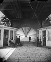
| Date: | 1877 |
|---|---|
| Description: | View towards men and women sitting and standing, beneath the lower deck of a suspension bridge (train uses upper deck). There are two booths (for tolls or ... |
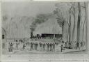
| Date: | 06 1862 |
|---|---|
| Description: | First train crossing the Obion River, Tennessee, on the Ohio and Mobile Railroad on a bridge built by the 12th Wisconsin Volunteers. Watercolor by John Ga... |

| Date: | 1859 |
|---|---|
| Description: | Map featuring various views of buildings and scenes from Sauk County. |
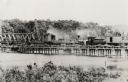
| Date: | 1885 |
|---|---|
| Description: | Partial removal of railroad bridge over Rock River. A train is on a section not being removed in order to transport men and materials. |

| Date: | 06 1899 |
|---|---|
| Description: | Elevated view of New Richmond after the tornado hit on June 12, 1899. Many people are gathered around the railroad tracks and a few others are seen among t... |

| Date: | 1878 |
|---|---|
| Description: | View from riverbank of the Chicago Milwaukee and St. Paul railroad locomotive no. 142 on the Kilbourn bridge. |
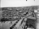
| Date: | 06 12 1899 |
|---|---|
| Description: | Elevated view toward the horizon over a bridge on a river of the widespread destruction left in the wake of a tornado. Destroyed houses litter the scene an... |

| Date: | 1875 |
|---|---|
| Description: | The City of Fort Howard, Brown County, Wisconsin. Compiled from the records and drawn by F.E. Predergast, of De Pere. |
If you didn't find the material you searched for, our Library Reference Staff can help.
Call our reference desk at 608-264-6535 or email us at: