 Filter: Categories of Wisconsin Historical Images
Filter: Subject of Public utilities
Filter: Year of 1900-1999
Filter: Categories of Wisconsin Historical Images
Filter: Subject of Public utilities
Filter: Year of 1900-1999

| Date: | 1918 |
|---|---|
| Description: | A boy holds the door handle of a circa 1916 Model T Ford with a modified radiator cover. A girl walks up the road toward the car. There is a bridge over a ... |
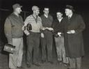
| Date: | 11 01 1966 |
|---|---|
| Description: | Wisconsin Congressman Melvin Laird distributing his campaign literature outside the Marathon Electric plant gate. |

| Date: | 1903 |
|---|---|
| Description: | This map is ink on printed paper reading: "standard profile plate." "Surveyed Oct. 15, platted Dec. 15, 1903 ; surveyed May 9, platted Dec. 9." |
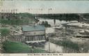
| Date: | 1908 |
|---|---|
| Description: | Colorized photographic postcard of an elevated view of the power station next to the river. A bridge is in the background. Caption reads: "Power Station, B... |
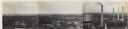
| Date: | 1930 |
|---|---|
| Description: | Panoramic elevated view to the northeast from the Capitol Square. |
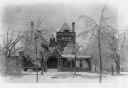
| Date: | 1922 |
|---|---|
| Description: | Trees broken and bowed under the weight of a heavy coating of ice stand in front of the Al. Ringling home. Limbs litter the snow-covered ground. Ice is on ... |
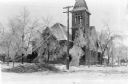
| Date: | 1922 |
|---|---|
| Description: | Downed wires and broken tree limbs mar the scene in front of the First Congregational Church at 131 6th Avenue. |

| Date: | 05 27 1964 |
|---|---|
| Description: | Seen from the rear, Carl Forsberg, president of Wisconsin Power and Light (WPL) company, is addressing a crowd of about 400 shareholders during a meeting a... |
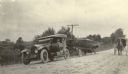
| Date: | 1920 |
|---|---|
| Description: | A National brand automobile is stopped on the side of an unpaved road as a horse-drawn buggy approaches from the rear. The car is pulling a racing yacht on... |

| Date: | 06 30 1965 |
|---|---|
| Description: | Steam pipe construction along Langdon street east of Park street. The corner of the Wisconsin Historical Society is on the left. Science Hall is in the bac... |

| Date: | 01 13 1914 |
|---|---|
| Description: | Smoke billowing from windows on the State Street (left) and Carroll Street (right) sides of the Wisconsin Building. Fire fighters on ladders are working fr... |

| Date: | 01 13 1914 |
|---|---|
| Description: | A policeman, center, keeping an eye on bystanders as firemen on ladders fight a fire at the Wisconsin Building on State Street. The building housed the Com... |

| Date: | 08 13 1965 |
|---|---|
| Description: | H.O. Lord, Madison Metropolitan Sewerage District chief engineer, outlining the existing sewerage district on a map. Lord is trying to educate the public c... |
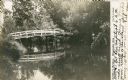
| Date: | 1905 |
|---|---|
| Description: | View across water towards a rustic wooden walking bridge which is reflected in the water of the Montello River. There is a utility pole with wires in the b... |

| Date: | 1906 |
|---|---|
| Description: | The printed inscription identifies this scene, "Looking South on Main Street, Montello, Wis." A woman is standing on the sidewalk at left near a parked bug... |
| Date: | 1974 |
|---|---|
| Description: | This blue line map show gas services and county boundaries. Includes a legend of company names in lower left hand corner. |
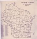
| Date: | 11 1973 |
|---|---|
| Description: | This map shows the cities, county boundaries and telephone exchange locations. The map includes a numbered list of telephone companies. |
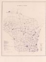
| Date: | 06 1975 |
|---|---|
| Description: | This map shows electrical utilities and cooperatives throughout the state, as well as cities and county boundaries. The bottom left corner of the map inclu... |

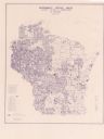
| Date: | 1973 |
|---|---|
| Description: | This map is 1 of 7 and includes a location map and township diagram in the margins. The map includes a key of land type: Residential (yellow), Commercial (... |

| Date: | 1973 |
|---|---|
| Description: | This map is 2 of 7 and includes a location map and township diagram in the bottom margin. The map includes a key of land type: Residential (yellow), Commer... |
If you didn't find the material you searched for, our Library Reference Staff can help.
Call our reference desk at 608-264-6535 or email us at: