 Filter: Categories of Wisconsin Historical Images
Filter: Subject of Prairies
Filter: Subject of military camps
Filter: Categories of Wisconsin Historical Images
Filter: Subject of Prairies
Filter: Subject of military camps
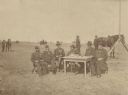
| Date: | 09 1887 |
|---|---|
| Description: | Outdoor group portrait of six men sitting around a table in military uniform in an open field. On the table are pens, an inkwell, two cigar boxes and paper... |

| Date: | 1900 |
|---|---|
| Description: | This map shows portion of the military road from Fond du Lac to the Wisconsin River near Fort Winnebago, with mile markers and adjacent land use. A few pro... |

| Date: | 10 1776 |
|---|---|
| Description: | Broadside map showing the British invasion of New York city in August and September of 1776. The map shows important cities, forts, roads, hills, mountains... |
If you didn't find the material you searched for, our Library Reference Staff can help.
Call our reference desk at 608-264-6535 or email us at: