 Filter: Categories of Wisconsin Historical Images
Filter: Subject of Potawatomi Indians
Filter: Subject of water
Filter: Categories of Wisconsin Historical Images
Filter: Subject of Potawatomi Indians
Filter: Subject of water

| Date: | 1962 |
|---|---|
| Description: | A map showing the location of Indian settlements in Wisconsin, indicating the settlements of the Chippewa, or Ojibwe, at St. Croix, Lac Courte Oreilles, Re... |

| Date: | 1979 |
|---|---|
| Description: | A map of Southern Wisconsin and northern Illinois showing the areas inhabited by the Ho-Chuck, formerly known as the Winnebago. Some of the location names ... |

| Date: | 11 14 1942 |
|---|---|
| Description: | This pictorial map illustrates Potawatomi Indian legends from the region of Lower Phantom Lake, labeled Howitt Lake on the map, Phantom Lake, and Mukwonag... |
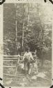
| Date: | 1920 |
|---|---|
| Description: | Outdoor portrait of a man standing near a spring in a wooded area surrounded by a wooden fence. He wears coveralls and holds two pails with a yoke over his... |

| Date: | 1920 |
|---|---|
| Description: | Full-length portrait of Potawatomi chief Simon Kahquados, born Kakanisaiga. He is depicted in his peace council attire. Caption reads: "A POTAWATOMI CHIEF.... |
If you didn't find the material you searched for, our Library Reference Staff can help.
Call our reference desk at 608-264-6535 or email us at: