 Filter: Categories of Wisconsin Historical Images
Filter: Subject of Postal service
Filter: Community of Milwaukee
Filter: Categories of Wisconsin Historical Images
Filter: Subject of Postal service
Filter: Community of Milwaukee

| Date: | 1886 |
|---|---|
| Description: | A hand-colored map of Milwaukee County, Wisconsin that shows the township and range system, sections, towns, roads, railroads and rail stations, cities and... |

| Date: | 1891 |
|---|---|
| Description: | A hand-colored map of Milwaukee County, Wisconsin that shows the township and range system, sections, towns, roads, railroads and rail stations, cities and... |

| Date: | 1902 |
|---|---|
| Description: | A map of Milwaukee County, Wisconsin that shows the township and range system, sections, towns, roads, railroads and rail stations, cities and villages, po... |

| Date: | 1880 |
|---|---|
| Description: | Map created from original drawing and surveys taken by Silas Chapman. Bottom right corner features a reference key. There is a street guide on the left sid... |
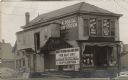
| Date: | 1908 |
|---|---|
| Description: | View the from the street of a building being remodeled to accommodate two businesses: a drugstore on the ground floor and a postal sub-station on the secon... |

| Date: | 1891 |
|---|---|
| Description: | This map shows railroads, street railways, roads, wards, block numbers, parks, and one mile concentric circles indicating distance from Post Office. Also i... |

| Date: | 1894 |
|---|---|
| Description: | This map shows railroads, street railways, roads, wards, block numbers, parks, Lake Michigan, and one mile concentric circles indicating distance from the ... |
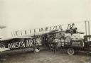
| Date: | 1919 |
|---|---|
| Description: | Slightly elevated view of men loading bags marked "U.S. Mail" from a truck into a Lawson Airliner No. 2. Alfred Lawson in his flight gear is standing on a ... |
If you didn't find the material you searched for, our Library Reference Staff can help.
Call our reference desk at 608-264-6535 or email us at: