 Filter: Categories of Wisconsin Historical Images
Filter: Subject of Portraits
Filter: Subject of rivers
Filter: Categories of Wisconsin Historical Images
Filter: Subject of Portraits
Filter: Subject of rivers
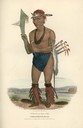
| Date: | 1835 |
|---|---|
| Description: | Cut-taa-tas-tia, a celebrated Chief of the Fox Tribe. Hand-colored lithograph from the Aboriginal Portfolio, was drawn at the Treaty of Prairie du Chien (1... |
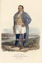
| Date: | 1835 |
|---|---|
| Description: | Francis Godfroy, a celebrated Miami chief who was half French and half Miami. Hand-colored lithograph from the Aboriginal Portfolio, painted at the Treaty ... |
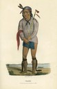
| Date: | 1835 |
|---|---|
| Description: | A Sioux Chief. Hand-colored lithograph from the Aboriginal Portfolio, painted at the Treaty of Prairie du Chien (1825). He holds a pipe. |
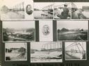
| Date: | 1914 |
|---|---|
| Description: | Multiple views of Oslo. Some pictured are the woolen mill and the dam. |

| Date: | 1861 |
|---|---|
| Description: | This map was reproduced photographically and issued in Augusta, Ga., in the early days of the Civil War. It includes panels showing Virginia, Maryland, the... |

| Date: | 1979 |
|---|---|
| Description: | A map of Southern Wisconsin and northern Illinois showing the areas inhabited by the Ho-Chuck, formerly known as the Winnebago. Some of the location names ... |

| Date: | 1860 |
|---|---|
| Description: | This map of Dodge County, Wisconsin, shows the township and range grid, towns, sections, cities and villages, railroads, roads, property owners and acreage... |

| Date: | 1835 |
|---|---|
| Description: | Shows Walker’s Point, Juneau Town and Kilbourn Town, including labeled buildings, trails and Indian villages. Relief shown by hachures. Oriented with north... |
If you didn't find the material you searched for, our Library Reference Staff can help.
Call our reference desk at 608-264-6535 or email us at: