 Filter: Categories of Wisconsin Historical Images
Filter: Subject of Ponds
Filter: Categories of Wisconsin Historical Images
Filter: Subject of Ponds

| Date: | 09 1969 |
|---|---|
| Description: | Arched bridge across small pond in Sid's backyard. In the background are a Japanese structure and Fudog lantern. |

| Date: | 06 1971 |
|---|---|
| Description: | Sid's backyard with a small concrete pond and bamboo, Cedar trees and a fence. Madison-Kipp Corporation is in the background. |

| Date: | 02 1777 |
|---|---|
| Description: | Map depicting the campaigns of October and November 1776, in Manhattan, Westchester, and part of New Jersey, published only a few months after the conclusi... |

| Date: | 1789 |
|---|---|
| Description: | Map of New York City showing ward boundaries, ferries, streets, roads, swamps, ponds, and rivers. The properties of Lispinard, Byards, Jones, Rutgers, and ... |

| Date: | 1776 |
|---|---|
| Description: | Fairly detailed map of New York City and parts of Long Island. It shows streets, roads, wharves, ferries, ship yards, Fort George and the battery, public b... |

| Date: | 1769 |
|---|---|
| Description: | Map of New Orleans at the start of the French & Indian War, including two inset maps of the Mississippi River Delta and Fort la Balise. It shows streets, r... |

| Date: | 1761 |
|---|---|
| Description: | Map of New Orleans with north oriented towards the upper right corner. It shows the land around the city, the Mississippi River, anchorages, roads leading ... |

| Date: | 1899 |
|---|---|
| Description: | An album page decorated with a hand-painted stem of wild geranium flowers features four photographs of Stuart Fargo, age two years, and his sister Dorothy,... |

| Date: | |
|---|---|
| Description: | View of the pond and fountain in Taylor Park. Trees are in the background, obscuring the houses across the street. Caption reads: "View in Taylor Park, Fon... |

| Date: | 1993 |
|---|---|
| Description: | Snow covered trees are growing out of a small island on a lagoon, with more trees lining the shore. In the distance are the central buildings of Northern I... |

| Date: | 1993 |
|---|---|
| Description: | The bare branches of a willow tree are obscuring the view of a snow covered lagoon. On the opposite shoreline is the main gate and entrance to Northern Ill... |

| Date: | 09 13 2014 |
|---|---|
| Description: | Shoveler's Sink, a small pond, sitting in a valley of small hills dotted with trees. Ducks are swimming in the lower left portion of the pond. |

| Date: | 09 18 2014 |
|---|---|
| Description: | View along shoreline towards a stone, arched bridge over the lagoon at Vilas Park. Lily pads are on the surface of the lagoon, and trees, tall grasses and ... |

| Date: | 10 15 2014 |
|---|---|
| Description: | Portrait of Ralph Quinney, standing with his right hand on the trunk of a tree. He is wearing eyeglasses, and a baseball cap with the word "Cabela's" writt... |

| Date: | 10 15 2014 |
|---|---|
| Description: | Portrait of the photographer, Richard Quinney. He is wearing a black jacket, eyeglasses, and a white baseball cap, and is standing with his right hand rest... |

| Date: | 03 24 2015 |
|---|---|
| Description: | View across snowy field towards a pond. |
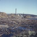
| Date: | 1957 |
|---|---|
| Description: | View from shoreline of logs floating in the water of Neopit Mill Pond. The sawmill is across the water, partially obscured by tall piles of logs. |

| Date: | 09 22 1927 |
|---|---|
| Description: | View from grassy shoreline towards a watermill with a thatched roof. |
If you didn't find the material you searched for, our Library Reference Staff can help.
Call our reference desk at 608-264-6535 or email us at:

