 Filter: Categories of Wisconsin Historical Images
Filter: Subject of Ponds
Filter: Subject of transportation
Filter: Categories of Wisconsin Historical Images
Filter: Subject of Ponds
Filter: Subject of transportation

| Date: | 1912 |
|---|---|
| Description: | Marinette County, Township 36 N., Range 20 E. |

| Date: | 1912 |
|---|---|
| Description: | Marinette County, Fract. Township 37 N., Ranges 21 and 22 E. |

| Date: | 1900 |
|---|---|
| Description: | This map shows logging roads, railroads with spur lines, trails, rapids, lumber camps, Indian villages, summer resort, lakes, rivers, and ponds. |

| Date: | |
|---|---|
| Description: | View of a mill from across the mill pond. |

| Date: | 1941 |
|---|---|
| Description: | This map shows heavy and light industry, residences, and business districts as well as streets and Mill Pond. The front and back of the map include extensi... |

| Date: | 1910 |
|---|---|
| Description: | This set of manuscript blueprint maps show block and lot numbers, railroads, and some landownership, including lands and buildings of J.S. Owen Lumber Co. ... |

| Date: | 1967 |
|---|---|
| Description: | View of Sid's backyard looking towards the back of the house. There is a large arch in the center with wind chimes hanging on it. Shrubs, trees, plants and... |

| Date: | 02 2014 |
|---|---|
| Description: | Two young men are playing hockey on the lagoon at Tenney Park. Snow is on the ground and the small foot bridge is in the background. |
| Date: | 1994 |
|---|---|
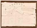
| Description: | This cadastral map shows Mill Pond, buildings, some landowners, cemetery, and out-lots. The upper right corner includes a statement about Ceresco. |

| Date: | 1970 |
|---|---|
| Description: | Elevated view of Sid Boyum's background taken from the second floor of his house. There is a large arch in the center with wind chimes hanging on it. Shrub... |

| Date: | 1970 |
|---|---|
| Description: | View of Sid Boyum's backyard. There is a large arch in the center with wind chimes hanging on it. Shrubs, trees, plants and other sculptures are on either ... |
| Date: | |
|---|---|
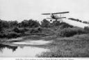
| Description: | View of a crop duster spraying a pesticide to control Malaria mosquitoes over a pond. The caption under the image reads: "Aerial 'Gas' Attack Annihilates a... |

| Date: | |
|---|---|
| Description: | Cast concrete sculpture of headless female form, mounted on square base in Sid's backyard, under the Tea Garden archway. In the foreground is a small arche... |

| Date: | 09 1969 |
|---|---|
| Description: | Arched bridge across small pond in Sid's backyard. In the background are a Japanese structure and Fudog lantern. |

| Date: | 02 1777 |
|---|---|
| Description: | Map depicting the campaigns of October and November 1776, in Manhattan, Westchester, and part of New Jersey, published only a few months after the conclusi... |

| Date: | 1789 |
|---|---|
| Description: | Map of New York City showing ward boundaries, ferries, streets, roads, swamps, ponds, and rivers. The properties of Lispinard, Byards, Jones, Rutgers, and ... |

| Date: | 1776 |
|---|---|
| Description: | Fairly detailed map of New York City and parts of Long Island. It shows streets, roads, wharves, ferries, ship yards, Fort George and the battery, public b... |

| Date: | 1769 |
|---|---|
| Description: | Map of New Orleans at the start of the French & Indian War, including two inset maps of the Mississippi River Delta and Fort la Balise. It shows streets, r... |

| Date: | 1761 |
|---|---|
| Description: | Map of New Orleans with north oriented towards the upper right corner. It shows the land around the city, the Mississippi River, anchorages, roads leading ... |

| Date: | 1899 |
|---|---|
| Description: | An album page decorated with a hand-painted stem of wild geranium flowers features four photographs of Stuart Fargo, age two years, and his sister Dorothy,... |
If you didn't find the material you searched for, our Library Reference Staff can help.
Call our reference desk at 608-264-6535 or email us at: