 Filter: Categories of Wisconsin Historical Images
Filter: Subject of Ponds
Filter: Subject of military art and science
Filter: Categories of Wisconsin Historical Images
Filter: Subject of Ponds
Filter: Subject of military art and science

| Date: | 1904 |
|---|---|
| Description: | Hand-colored stereograph of Mattie Sprague Attoe Du Mond holding a .22 rifle and standing on a fallen tree limb over the fish pond off Pine River on the pr... |
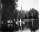
| Date: | 07 30 1899 |
|---|---|
| Description: | View across pond of Syl at Soldiers Home with aunt Helen standing on a landing near a boat and a flagpole. There is a large group of people gathered around... |

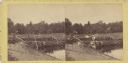
| Date: | 1866 |
|---|---|
| Description: | View of earthworks at the battlefield at Resacca. Dirt roads cross the field in the distance, leading to a farm and what appears to be a river. Plate 22... |
| Date: | 07 1863 |
|---|---|
| Description: | Stereograph of McPherson's Woods, where General John Reynolds, commanding the First Corps of which Wisconsin's 2nd, 6th, and 7th regiments were a part, was... |

| Date: | 10 24 1943 |
|---|---|
| Description: | Robert Doyle's caption says it best, "The ol' swimmin' hole, South Pacific style. Every afternoon it is filled with shouting soldiers in their birthday sui... |

| Date: | 10 24 1943 |
|---|---|
| Description: | Robert Doyle's caption for Image ID: 99742 says it best, "The ol' swimmin' hole, South Pacific style. Every afternoon it is filled with shouting soldiers i... |

| Date: | 10 24 1943 |
|---|---|
| Description: | Three officers of General Walter Krueger's staff stand on a log in front of a swimming hole located on Goodenough Island, in the Solomon Sea, New Guinea (p... |

| Date: | 02 1777 |
|---|---|
| Description: | Map depicting the campaigns of October and November 1776, in Manhattan, Westchester, and part of New Jersey, published only a few months after the conclusi... |

| Date: | 1776 |
|---|---|
| Description: | Fairly detailed map of New York City and parts of Long Island. It shows streets, roads, wharves, ferries, ship yards, Fort George and the battery, public b... |

| Date: | 1769 |
|---|---|
| Description: | Map of New Orleans at the start of the French & Indian War, including two inset maps of the Mississippi River Delta and Fort la Balise. It shows streets, r... |

| Date: | 1761 |
|---|---|
| Description: | Map of New Orleans with north oriented towards the upper right corner. It shows the land around the city, the Mississippi River, anchorages, roads leading ... |
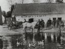
| Date: | 1918 |
|---|---|
| Description: | U.S. soldiers are standing in front of a stone farmhouse used for military housing in France. A pond with geese is in the foreground, and a horse is standi... |

| Date: | 1914 |
|---|---|
| Description: | German forces occupied Antwerp on October 10th, 1914 after a two week siege. |
If you didn't find the material you searched for, our Library Reference Staff can help.
Call our reference desk at 608-264-6535 or email us at: