 Filter: Categories of Wisconsin Historical Images
Filter: Subject of Ponds
Filter: Subject of maps
Filter: Categories of Wisconsin Historical Images
Filter: Subject of Ponds
Filter: Subject of maps

| Date: | 1941 |
|---|---|
| Description: | This map shows heavy and light industry, residences, and business districts as well as streets and Mill Pond. The front and back of the map include extensi... |

| Date: | 1910 |
|---|---|
| Description: | This set of manuscript blueprint maps show block and lot numbers, railroads, and some landownership, including lands and buildings of J.S. Owen Lumber Co. ... |
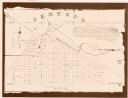
| Date: | 1994 |
|---|---|
| Description: | This cadastral map shows Mill Pond, buildings, some landowners, cemetery, and out-lots. The upper right corner includes a statement about Ceresco. |
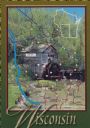
| Date: | 1988 |
|---|---|
| Description: | Text on front, at the foot: "Wisconsin." The color image of Hyde's Mill has an overlay of a map of the southwest corner of Wisconsin inside a red frame. Th... |
If you didn't find the material you searched for, our Library Reference Staff can help.
Call our reference desk at 608-264-6535 or email us at: