 Filter: Categories of Wisconsin Historical Images
Filter: Subject of Politics, Practical
Filter: Subject of human settlements
Filter: Categories of Wisconsin Historical Images
Filter: Subject of Politics, Practical
Filter: Subject of human settlements
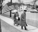
| Date: | 11 10 1956 |
|---|---|
| Description: | Bet winner and Eisenhower supporter Edwin L. Warner enjoys his payoff from bet loser and Adlai Stevenson backer John Shaat, as Shaat tows Warner along the ... |

| Date: | 1772 |
|---|---|
| Description: | Scale: about 180 miles to 1 in. |
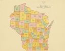
| Date: | 1922 |
|---|---|
| Description: | A map of Wisconsin showing the state’s Assembly Districts. It also provides the population total of each county. |

| Date: | 1911 |
|---|---|
| Description: | Map printed in the Milwaukee Herald, 16th of February, 1912. Includes list of Assembly, State Senate, and Congressional districts in bottom margin. Contain... |
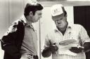
| Date: | 06 1986 |
|---|---|
| Description: | Jerry Zarecki (in the hat), president of the Portage County Farmers Union, presents Wisconsin Congressman David R. Obey with one folder of petitions collec... |

| Date: | |
|---|---|
| Description: | The parliament building in Cettinje, Montenegro. |
If you didn't find the material you searched for, our Library Reference Staff can help.
Call our reference desk at 608-264-6535 or email us at: