 Filter: Categories of Wisconsin Historical Images
Filter: Subject of Plazas
Filter: Subject of water
Filter: Categories of Wisconsin Historical Images
Filter: Subject of Plazas
Filter: Subject of water

| Date: | 03 03 1957 |
|---|---|
| Description: | A view of Olin Terrace. The terrace and fountain were built in 1934 by CWA and FERA workers. It was designed by Frank Riley, Madison architect, in the Ital... |

| Date: | 07 20 1987 |
|---|---|
| Description: | A little girl offers her place at a fountain to a large Newfoundland-mix dog who takes a drink on a hot day. |
| Date: | 1908 |
|---|---|
| Description: | Drawing of lower campus development of the University of Wisconsin Madison campus, designed by Arthur Peabody. Left to right along Lake Street are the Mus... |
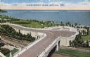
| Date: | |
|---|---|
| Description: | Elevated view of Lincoln Memorial Bridge and plaza area. Lake Michigan is in the background, railroad tracks are below the bridge. Trees and grass surround... |

| Date: | |
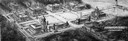
|---|---|
| Description: | An aerial view of the port and a section of the city showing a large boat, a railway depot, a park plaza and a grid of city streets with large buildings. |

| Date: | 1913 |
|---|---|
| Description: | Elevated view of shoreline, waterfront buildings, boat-dotted bay and Perry's Victory and International Peace Memorial. The pink-marble, column-shaped monu... |

| Date: | 1968 |
|---|---|
| Description: | A small crowd mills about a cobblestone plaza near a brick building on the wharf adjacent to the Hudson River. The Queen Elizabeth 2 cruise ship is ... |

| Date: | 1835 |
|---|---|
| Description: | Plat for a proposed Sinsinawa City (never built), in Grant County, Wis. When it became clear in the mid-1830s that Wisconsin Territory would be established... |

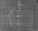
| Date: | 1836 |
|---|---|
| Description: | This is a cadastral map and shows proposed lot and block numbers for a paper city on the banks of the Rock River. Also shown are two public squares and som... |

| Date: | |
|---|---|
| Description: | Elevated view of the flagstone terrace. People sit at tables in the sunburst chairs. There are shadows of the empty chairs on the terrace as well as the s... |

| Date: | 1835 |
|---|---|
| Description: | Map shows the Fox River, lot and block numbers, private claims, streets, a public squares, a manual labour school, and Fort Howard. An inset map shows a pl... |
| Date: | 1900 |
|---|---|
| Description: | Plat map showing a paper city located on the Wisconsin River. The map includes a public square, street names, and a note written by Francis Headman. |

| Date: | 08 31 1979 |
|---|---|
| Description: | A young couple enjoys each other's company among others on a beautiful day at Library Mall on the campus of UW-Madison. |
If you didn't find the material you searched for, our Library Reference Staff can help.
Call our reference desk at 608-264-6535 or email us at: