 Filter: Categories of Wisconsin Historical Images
Filter: Subject of Pioneers
Filter: Year of 1900-1999
Filter: Year of 1940-1949
Filter: Categories of Wisconsin Historical Images
Filter: Subject of Pioneers
Filter: Year of 1900-1999
Filter: Year of 1940-1949

| Date: | 02 04 1945 |
|---|---|
| Description: | Colonial period travel by stagecoach which is halted at an inn and the horses are being changed, some of the passengers are getting off, one of four murals... |
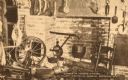
| Date: | 1940 |
|---|---|
| Description: | A spinning wheel, chair, and other kitchen objects in the corner of a room. Caption reads: "Corner of Pioneer Kitchen, Douglas County Historical Museum, Su... |
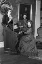
| Date: | 12 01 1944 |
|---|---|
| Description: | Reenacting a pioneer Christmas custom of many foreign settlers in the early days of Wisconsin of singing carols around the family organ, are left to right:... |

| Date: | 08 19 1946 |
|---|---|
| Description: | Portrait of Mrs. Jane Duff, a Dane County pioneer resident, on her 90th birthday. |

| Date: | 01 10 1948 |
|---|---|
| Description: | Portrait painting of Kit Carson, a famous trapper and guide of the west. The painting is leaning on a wall, with part of another painting on the right. Par... |
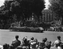
| Date: | 05 29 1948 |
|---|---|
| Description: | Wisconsin Centennial Parade near the Wisconsin State Capitol. The Blue Mounds float depicting Dane County's first settler, Ebenezer Brigham, is coming down... |
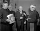
| Date: | 03 04 1949 |
|---|---|
| Description: | Bishop William P. O'Connor presents the medal of Benemerenti to Frank Blied, a member of a pioneer Madison family. The medal, awarded by Pope Pius XII, is ... |

| Date: | 12 25 1942 |
|---|---|
| Description: | This hand-drawn map shows the highways and features in the Rock Lake-Lake Mills area in the towns of Aztalan and Lake Mills, Jefferson County, Wisconsin. T... |
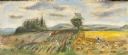
| Date: | 1948 |
|---|---|
| Description: | Prior to the 1948 State Fair, artist Robert Hodgell traveled Wisconsin to study its many landscapes. He then produced a series of study sketches outlining ... |

| Date: | 1940 |
|---|---|
| Description: | This map of Aztalan is pencil and ink on paper. The map shows streets, local businesses, churches, houses, and the Crawfish River. The map reads: "Informat... |

| Date: | 1942 |
|---|---|
| Description: | This pictorial bird's-eye-view map shows the United States of America with parts of Canada and Mexico. Landscape, trade, industry, points of interest, peop... |

| Date: | 1946 |
|---|---|
| Description: | This map shows scenes from America's history with names of historical events superimposed on a map of the United States. |
If you didn't find the material you searched for, our Library Reference Staff can help.
Call our reference desk at 608-264-6535 or email us at: