 Filter: Categories of Wisconsin Historical Images
Filter: Subject of Pioneers
Filter: Subject of rivers
Filter: Categories of Wisconsin Historical Images
Filter: Subject of Pioneers
Filter: Subject of rivers

| Date: | 1855 |
|---|---|
| Description: | Map reads "Our Country" which is accompanied by a sailor with a flag to the left and workers rejoicing under the Constitution and Laws to the right. Across... |
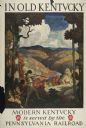
| Date: | 1930 |
|---|---|
| Description: | An original lithograph promoting Kentucky and the Pennsylvania Railroad through an artist's depiction of two men dressed in buckskin, wearing raccoon hats ... |

| Date: | 1937 |
|---|---|
| Description: | Label submitted to the state of Wisconsin for trademark registration. "Pioneer Beer, G. Weber Brewing Co." Under this in the center is a leaf with the lett... |

| Date: | 12 25 1942 |
|---|---|
| Description: | This hand-drawn map shows the highways and features in the Rock Lake-Lake Mills area in the towns of Aztalan and Lake Mills, Jefferson County, Wisconsin. T... |

| Date: | 05 1995 |
|---|---|
| Description: | "Pioneer reenactors set up their tents on the Rock River in Mayville." |

| Date: | 1940 |
|---|---|
| Description: | This map of Aztalan is pencil and ink on paper. The map shows streets, local businesses, churches, houses, and the Crawfish River. The map reads: "Informat... |

| Date: | 1888 |
|---|---|
| Description: | This is a reproduction of a map originally published in 1829 by R.W. Chandler, a pioneer settler of Galena. It is based on an earlier map by surveyor Luciu... |

| Date: | 1937 |
|---|---|
| Description: | Pictorial map showing historical events and locations within the state of Wisconsin, as well as waterways and counties. Original caption on the bottom marg... |
| Date: | 1998 |
|---|---|
| Description: | This map shows the number of Welsh-born heads of households around 1870. A small inset map in the lower left corner shows Welsh land ownership in the heart... |

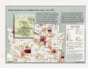
| Date: | 1929 |
|---|---|
| Description: | This map with north oriented to the upper left shows military forts, Indian villages, settler's houses with surnames, trading houses, lodges and encampment... |
If you didn't find the material you searched for, our Library Reference Staff can help.
Call our reference desk at 608-264-6535 or email us at: