 Filter: Categories of Wisconsin Historical Images
Filter: Subject of Parks
Filter: Year of 1800-1899
Filter: Categories of Wisconsin Historical Images
Filter: Subject of Parks
Filter: Year of 1800-1899

| Date: | 1883 |
|---|---|
| Description: | Caption on reverse side of stereograph reads: "Governmental buildings, Wisconsin Conservatory of Music and Hospital over Lake Mendota-looking from Capitol ... |
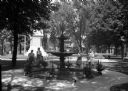
| Date: | 1898 |
|---|---|
| Description: | Four girls are each standing behind a child sitting in a stroller while posing around Lewis Fountain in Veteran's Park. Houses and the Civil War Veteran's ... |

| Date: | 1878 |
|---|---|
| Description: | This map shows block numbers, wards, roads, railroads, parks, and selected buildings and includes a "Milwaukee city street guide" as well as a guide to pub... |

| Date: | 1887 |
|---|---|
| Description: | This map shows block numbers, roads, railroads, wards, and selected buildings. The map includes a "Milwaukee city street guide" and index to public buildin... |

| Date: | 1854 |
|---|---|
| Description: | This map is ink and watercolor on tracing cloth and shows lot and block numbers, streets, a park, and depots. Some lots are colored red or blue and some in... |

| Date: | 1898 |
|---|---|
| Description: | A hydrographic map of Lake Geneva that includes 15 cross sections of the depths at various points as well as a line running the length of the lake from Gen... |

| Date: | 1891 |
|---|---|
| Description: | A hand-colored map of Milwaukee County, Wisconsin that shows the township and range system, sections, towns, roads, railroads and rail stations, cities and... |

| Date: | 1898 |
|---|---|
| Description: | This map shows the contour depths of Delavan Lake and the Lauderdale Lakes in Walworth County, Wisconsin, and includes nine cross sections of the lakes. Ro... |

| Date: | 1898 |
|---|---|
| Description: | This 1898 map shows the contour depths of the Chain O' Lakes in Waupaca County, Wisconsin, and includes 15 cross sections of the lakes. Roads, parks, the W... |

| Date: | 1898 |
|---|---|
| Description: | Map showing the contour depths of the lakes in northwestern Waukesha County, Wisconsin. Roads, railroads, depots, churches, schools, and hotels in the area... |

| Date: | 1886 |
|---|---|
| Description: | Engraved image from a sketch by Theodore Davis showing four men bicycling. |

| Date: | 1889 |
|---|---|
| Description: | Bird’s-eye-view map. Published in the Milwaukee Sentinel: Wednesday morning, August 28, 1889 for the 23rd National Encampments of the GAR, August 27... |

| Date: | 1896 |
|---|---|
| Description: | Map highlighting parks and other points of interest in Milwaukee. |
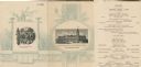
| Date: | 08 01 1889 |
|---|---|
| Description: | Exterior and interior menu listing of the Fountain Spring House, with visitors strolling the grounds of a tree-filled park with the hotel in the background... |

| Date: | 1880 |
|---|---|
| Description: | This map of La Crosse shows the Chicago, Milwaukee and St. Paul Railroad, the Southern Minnesota Railroad and the Chicago, Dubuque and Minnesota Railroad, ... |

| Date: | 1893 |
|---|---|
| Description: | This map of La Crosse shows city ward boundaries in red, streets, railroads, cemeteries, Grand station crossing, the road to French Island, depots, Lake Pa... |
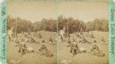
| Date: | 1885 |
|---|---|
| Description: | Scattered figures of a picnic party on a grassy slope. |

| Date: | 1888 |
|---|---|
| Description: | This map has relief shown by hachures and features inset maps of a plat of E.D. Clinton and Blackwell’s add’n to the City of La Crosse. Wards (1-10) shaded... |

| Date: | 1890 |
|---|---|
| Description: | This map is a plat map and shows government buildings, churches, Klein’s Park, and the government dam in Kaukauna. The map includes text about Kaukauna wit... |

| Date: | 1857 |
|---|---|
| Description: | This map has relief shown by hachures and pictorially and shows plat of the town, wards, lots, land ownership by name, local roads, highways, railroads, pa... |
If you didn't find the material you searched for, our Library Reference Staff can help.
Call our reference desk at 608-264-6535 or email us at: