 Filter: Categories of Wisconsin Historical Images
Filter: Subject of Parks
Filter: Subject of postal service
Filter: Categories of Wisconsin Historical Images
Filter: Subject of Parks
Filter: Subject of postal service

| Date: | 1876 |
|---|---|
| Description: | "View of the Capitol, with all the Flags" one of four "Different Views of Parades in the Streets" identified in Dahl's 1877 "Catalogue of Stereoscopic View... |

| Date: | 1890 |
|---|---|
| Description: | A view looking down Wisconsin Avenue as seen from the Wisconsin State Capitol grounds. On the right, the post office is visible. |

| Date: | 1891 |
|---|---|
| Description: | A hand-colored map of Milwaukee County, Wisconsin that shows the township and range system, sections, towns, roads, railroads and rail stations, cities and... |

| Date: | 1902 |
|---|---|
| Description: | A map of Milwaukee County, Wisconsin that shows the township and range system, sections, towns, roads, railroads and rail stations, cities and villages, po... |

| Date: | 1927 |
|---|---|
| Description: | This map includes an index and highways marked in red. Attractions on the map include: Four Mile House, Cold Springs, Grand Crossing Station, Coleman Sloug... |

| Date: | 1891 |
|---|---|
| Description: | This map shows railroads, street railways, roads, wards, block numbers, parks, and one mile concentric circles indicating distance from Post Office. Also i... |
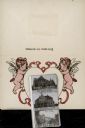
| Date: | 1907 |
|---|---|
| Description: | Inside of folded postcard-size card, with an illustration of two cherubs/angels on each side of a heart shape. Inside the heart is a glued and multi-folded... |
If you didn't find the material you searched for, our Library Reference Staff can help.
Call our reference desk at 608-264-6535 or email us at: