 Filter: Categories of Wisconsin Historical Images
Filter: Subject of Parks
Filter: Subject of airports
Filter: Categories of Wisconsin Historical Images
Filter: Subject of Parks
Filter: Subject of airports

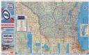
| Date: | 1933 |
|---|---|
| Description: | A road map of Wisconsin and Michigan’s Upper Peninsula, showing the populations of cities and villages, state and federal highways, national forests, state... |

| Date: | 1939 |
|---|---|
| Description: | This nine-part map from the U.S. Bureau of Public Roads identifies federal and state highways in Wisconsin by pavement type. County, forest, park, and publ... |

| Date: | 1944 |
|---|---|
| Description: | This nine-part map from the U.S. Bureau of Public Roads identifies federal and state highways in Wisconsin by pavement type. County, forest, park, and publ... |

| Date: | 1946 |
|---|---|
| Description: | A map showing the roads, railroads, towns, cities and villages, streams and lakes, airports, schools, churches, cemeteries, and golf courses in Kenosha Cou... |

| Date: | 02 1956 |
|---|---|
| Description: | This 1956 map of Waukesha County, Wisconsin, shows the township and range grid, towns, sections, cities and villages, roads, railroads, dams, airports, par... |

| Date: | 1987 |
|---|---|
| Description: | This 1987 map of Racine and Kenosha counties, Wisconsin, shows towns, sections, cities and villages, zip code boundaries, highways and roads, bicycle route... |

| Date: | 1970 |
|---|---|
| Description: | Color coded map. Legend in the top left hand corner reads: "EXISTING AIRPORT PAVEMENT" (purple), "FUTURE 5-YEAR DEVELOPMENT" (bright pink), "ULTIMATE AIRPO... |

| Date: | 1975 |
|---|---|
| Description: | This standard U.S.G.S. topographic map was annotated by civil engineer and railroad historian James P. Kaysen to show the location of existing and defunct ... |

| Date: | 1929 |
|---|---|
| Description: | This is a blue line print map that shows local streets, railroads, local businesses, schools, parks, cemeteries, the airport, the state capitol, the Univer... |

| Date: | 1982 |
|---|---|
| Description: | Color map. "Topography by photogrammetric methods from aerial photographs taken 1963. Revised from aerial photographs taken 1978. Field checked 1979. Map e... |

| Date: | 1962 |
|---|---|
| Description: | This map shows roads, golf courses, ski areas, boat landings, camp sites, waysides, parks, beaches, scenic views, virgin timber tracts, airports, boys and ... |

| Date: | 1962 |
|---|---|
| Description: | This map shows roads, golf courses, ski areas, boat landings, camp sites, waysides, parks, beaches, scenic views, virgin timber tracts, airports, boys and ... |

| Date: | 1938 |
|---|---|
| Description: | This map shows roads, parks, golf courses, airports, beaches, docks and harbors, lighthouses, and buoys within Winnebago County and parts of Waushara, Calu... |

| Date: | 1960 |
|---|---|
| Description: | This map shows U.S. highways, state highways, county highways, town roads, county parks, county highway buildings, waysides, rivers, lakes, airports, a civ... |

| Date: | 1966 |
|---|---|
| Description: | This blue line print shows existing and proposed streets, docks, company-owned land, railroads and railroad yards, parks, and municipal airport. |

| Date: | 1933 |
|---|---|
| Description: | This road map shows automobile routes across Wisconsin as well as portions of Illinois, Minnesota, Iowa and Michigan. Lakes Michigan, Superior and Winnebag... |

| Date: | 1933 |
|---|---|
| Description: | This map contains automobile routes across Wisconsin and portions of Illinois, Iowa, Minnesota and Michigan as well. The state borders are clearly defined... |

| Date: | 1935 |
|---|---|
| Description: | This colored road map comes with a map legend and explanation, as well as an index of cities and towns (and their populations) in Wisconsin. Information ab... |
| Date: | 1963 |
|---|---|
| Description: | This colored road map shows automobile roads in Wisconsin as well as portions of nearby states. The map is organized such that a single map of Wisconsin is... |
If you didn't find the material you searched for, our Library Reference Staff can help.
Call our reference desk at 608-264-6535 or email us at: