 Filter: Categories of Wisconsin Historical Images
Filter: Subject of Parks
Filter: County of Sheboygan
Filter: Categories of Wisconsin Historical Images
Filter: Subject of Parks
Filter: County of Sheboygan
| Date: | 1935 |
|---|---|
| Description: | View of Kohler Ravine Park. In the right foreground is a small bridge, and on the right is a set of wide, concrete steps leading from the road down the hil... |

| Date: | 1906 |
|---|---|
| Description: | Soldiers' Monument in Fountain Park. |

| Date: | 1905 |
|---|---|
| Description: | Sheridan Park with fountain in Sheboygan. Caption reads: "Sheridan Park, Sheboygan, Wis." |

| Date: | 1920 |
|---|---|
| Description: | View across street towards of Fountain Park. Caption reads: "Fountain Park, Sheboygan, Wis." |
| Date: | 1950 |
|---|---|
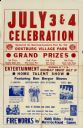
| Description: | Poster for the 4th of July celebration in Oostburg, Wisconsin. The featured entertainment consisted of acts for which the Ben Bergor Entertainment Agency w... |

| Date: | 1909 |
|---|---|
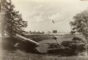
| Description: | Two women sit pensively on stone benches on either side of a muddy gravel path. The one on the left is Elsie. Near her in the background are four children.... |

| Date: | 1893 |
|---|---|
| Description: | This map shows wards, railroads, street cars, streets, lot and block numbers, landownership, parks, hospitals, the Sheboygan River, and Lake Michigan. Ward... |

| Date: | 1921 |
|---|---|
| Description: | This map shows Lake Michigan, the Sheboygan River, buildings, streets, churches, industrial yards, and parks. Relief is shown by hachures and depths are sh... |

| Date: | 1915 |
|---|---|
| Description: | This map shows wards, railroads, street railways, streets, lot and block numbers, parks, and hospitals. Also included are manuscript annotations of points ... |

| Date: | 1926 |
|---|---|
| Description: | This map includes a legend in the lower right corner of building heights. Districts marked "A" are 35 foot, districts marked "B" are 45 foot, districts mar... |

| Date: | 1926 |
|---|---|
| Description: | This map includes a legend in the lower right corner of land use. Districts are shown in five different shading for: "A" residential, "B" are residential, ... |

| Date: | 1940 |
|---|---|
| Description: | This map hows block and lot numbers, water mains, roads, parks, the Sheboygan River and some landownership. |
| Date: | 1908 |
|---|---|
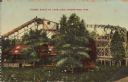
| Description: | Text on front reads: "Figure Eight at Lake View, Sheboygan, Wis." A rollercoaster at Lake View Park with trees and a flower filled lawn in the foreground. ... |

| Date: | 1907 |
|---|---|
| Description: | Text on front reads: "Bathing Beach, Sheboygan, Wis." View from water towards a large beach on the Lake Michigan shoreline. There is a crowd on the sand an... |

| Date: | 04 01 1905 |
|---|---|
| Description: | Text on front reads: "Sheboygan, Wis. the .......190." The person writing the postcard added the date and year. Four scenes are displayed within Art Nouvea... |

| Date: | 07 18 1938 |
|---|---|
| Description: | Text on front reads: "Vollrath Bowl, Sheboygan, Wis." The land was donated in 1917 by the Vollrath heirs and the construction of the Vollrath Park Zoo was ... |
If you didn't find the material you searched for, our Library Reference Staff can help.
Call our reference desk at 608-264-6535 or email us at: