 Filter: Categories of Wisconsin Historical Images
Filter: Subject of Parks
Filter: Community of La Crosse
Filter: Subject of mississippi river
Filter: Categories of Wisconsin Historical Images
Filter: Subject of Parks
Filter: Community of La Crosse
Filter: Subject of mississippi river
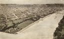
| Date: | 1900 |
|---|---|
| Description: | A drawing of Levee Park in La Crosse, with the Mississippi River in the foreground, and La Crosse in the background. |

| Date: | 1900 |
|---|---|
| Description: | Four-panel Panoramic view of La Crosse. Indentifiable businesses in view include: J. Hogan Wholesale Grocer, T.H. Spence Drug Co., Union Refrigerator Trans... |
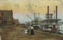
| Date: | 1910 |
|---|---|
| Description: | Caption reads: "Riverfront from Pettibone Park, La Crosse, Wis." There are three steamboats docked on the right in the harbor. A mother and her children ar... |

| Date: | 1880 |
|---|---|
| Description: | This map of La Crosse shows the Chicago, Milwaukee and St. Paul Railroad, the Southern Minnesota Railroad and the Chicago, Dubuque and Minnesota Railroad, ... |

| Date: | 1893 |
|---|---|
| Description: | This map of La Crosse shows city ward boundaries in red, streets, railroads, cemeteries, Grand station crossing, the road to French Island, depots, Lake Pa... |

| Date: | 1954 |
|---|---|
| Description: | This map of La Crosse shows residential, multiple dwelling, local business, commercial, light industrial, heavy industrial and special multiple dwelling la... |

| Date: | 1972 |
|---|---|
| Description: | This map of La Crosse is a plan for the city parks and recreation areas. The cover features an explanation of the Park and Recreation plan, objectives of t... |

| Date: | 1900 |
|---|---|
| Description: | This map of La Crosse shows twenty wards, some rural lots with acreages, streets, railroads, depots, bridges, cemeteries, parks, schools, islands, and the ... |

| Date: | 1888 |
|---|---|
| Description: | This map has relief shown by hachures and features inset maps of a plat of E.D. Clinton and Blackwell’s add’n to the City of La Crosse. Wards (1-10) shaded... |

| Date: | 1927 |
|---|---|
| Description: | This map includes an index and highways marked in red. Attractions on the map include: Four Mile House, Cold Springs, Grand Crossing Station, Coleman Sloug... |

| Date: | 1883 |
|---|---|
| Description: | This map shows ward boundaries, names of additions, streets, bridges, mills, schools, religious buildings, businesses, hotels, railroads, factories, brewer... |

| Date: | 1891 |
|---|---|
| Description: | This hand-colored map shows platted additions and subdivisions, ward boundaries, schools, churches, railroads, cemeteries, parks, businesses, factories, an... |
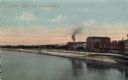
| Date: | 1914 |
|---|---|
| Description: | View across Mississippi River towards a riverside park. Buildings are along the right behind the park. Caption reads: "River Park, La Crosse, Wis." |

| Date: | 1942 |
|---|---|
| Description: | Black and white aerial view of La Crosse and the Mississippi River, including Riverside Park, the Black River and La Crosse River. |
| Date: | |
|---|---|
| Description: | View of the cannon at Riverside Park. Automobiles are parked by the river on the left. Caption reads: "Riverside Park, La Crosse, Wis." |
| Date: | |
|---|---|
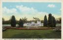
| Description: | View of flower beds in a park. An excursion boat is in the Mississippi River in the background. Caption reads: "One of the Many Pretty Flower Beds, Riversi... |

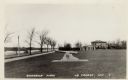
| Date: | 1950 |
|---|---|
| Description: | View of a driveway and sidewalk along the Mississippi River. An interstate bridge and bluffs are in the distance. Caption reads: "Driveway, Pettibone Park,... |

| Date: | |
|---|---|
| Description: | Hand-colored view of a circular flower bed next to the river, with an interstate bridge in the distance. Caption reads: "One of the Many Pretty Flower Beds... |

| Date: | |
|---|---|
| Description: | View along unpaved drive, bordered by lawn and trees. In the background on the right is a bridge over the river. Caption reads: "Pettibone Drive, Lovers' L... |
If you didn't find the material you searched for, our Library Reference Staff can help.
Call our reference desk at 608-264-6535 or email us at: