 Filter: Categories of Wisconsin Historical Images
Filter: Subject of Parks
Filter: Type of Map or Atlas
Filter: Subject of streets
Filter: Categories of Wisconsin Historical Images
Filter: Subject of Parks
Filter: Type of Map or Atlas
Filter: Subject of streets

| Date: | 1890 |
|---|---|
| Description: | Bird's-eye map of Ashland, viewed from Lake Superior, with insets of Prentice Park and Fishery. Population 16,000. Increase in Ten Years, 11,000. |

| Date: | 2007 |
|---|---|
| Description: | This map of Cedarbug is a bird's-eye map with 8 inset views and an index. The map is a print out of the original map dated 1892 held at the Cedarburg Cultu... |

| Date: | 1891 |
|---|---|
| Description: | Bird's-eye view of Eau Claire. |

| Date: | 1896 |
|---|---|
| Description: | Bird's-eye map of Fond du Lac, looking north west, with two insets of the P.H. Stamm residence, and the Proposed Lakeside Park. thirty-five locations ident... |

| Date: | 1896 |
|---|---|
| Description: | A portion of John B. Heim's map of the Water Works System of Madison showing the size of the third Wisconsin Capitol (228' x 226') in comparison with the C... |

| Date: | 1892 |
|---|---|
| Description: | Bird's-eye view of Chicago, with ships in the Lake Michigan harbor. |

| Date: | 1904 |
|---|---|
| Description: | This map shows a plat of the east part of the city, numbered blocks and lots, some landownership, local streets, roads, railroads, wards by number, parks, ... |

| Date: | 1904 |
|---|---|
| Description: | This map shows a plat of the west part of the city, numbered blocks and lots, some landownership, local streets, roads, railroads, wards by number, parks, ... |

| Date: | |
|---|---|
| Description: | Plat map of the east central part of the city. |

| Date: | 1854 |
|---|---|
| Description: | This map is ink and watercolor on tracing cloth and shows lot and block numbers, streets, a park, and depots. Some lots are colored red or blue and some in... |

| Date: | 1970 |
|---|---|
| Description: | A map of parks of Kewaunee County, Wisconsin, showing the fishing spots, lakes and parks in the area, it also provides a location map of the area. On the ... |

| Date: | 1891 |
|---|---|
| Description: | A hand-colored map of Milwaukee County, Wisconsin that shows the township and range system, sections, towns, roads, railroads and rail stations, cities and... |

| Date: | 1940 |
|---|---|
| Description: | Map of Milwaukee County showing the metropolitan area, in yellow, and the proposed connecting of parkways and boulevards in green. The map also identifies ... |

| Date: | 1976 |
|---|---|
| Description: | A street map of Milwaukee County, Wisconsin that identifies the location of schools, hospitals, parks, beaches, streets, freeways, both planned or under co... |

| Date: | 1947 |
|---|---|
| Description: | Shows lot and block numbers, 28 points of interest in the upper left that correspond to numbers on the map, and landownership with acreages. "Erickson Brot... |

| Date: | 1896 |
|---|---|
| Description: | Map highlighting parks and other points of interest in Milwaukee. |
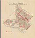
| Date: | 1916 |
|---|---|
| Description: | Shows streetlights, streets improvements, and sewer districts in red. Points of interest are labelled. Map reads: "Map of Tenth Ward Showing Improvements S... |

| Date: | 1928 |
|---|---|
| Description: | Illustrated map of points of interest, including University buildings, parks, athletic venues, fraternity and sorority houses, and state buildings. |

| Date: | 1956 |
|---|---|
| Description: | Includes street index. Shows local streets, parks, highways, railroads, Fond du Lac River, and part of lake Winnebago. Also includes text on points of inte... |

| Date: | 1956 |
|---|---|
| Description: | Includes street index and index to points of interest. Shows land ownership by name, plat of town, local streets, schools, parks, highways, railroads, ward... |
If you didn't find the material you searched for, our Library Reference Staff can help.
Call our reference desk at 608-264-6535 or email us at: