 Filter: Categories of Wisconsin Historical Images
Filter: Subject of Oneida Indians
Filter: Subject of military art and science
Filter: Categories of Wisconsin Historical Images
Filter: Subject of Oneida Indians
Filter: Subject of military art and science
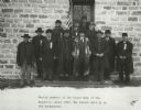
| Date: | 1907 |
|---|---|
| Description: | Oneida members of the Grand Army of the Republic. The Parish Hall is in the background. |

| Date: | 1848 |
|---|---|
| Description: | Map of Wisconsin and a portion of Minnesota showing the township surveys in progress in portions of the Saint Croix River region and in central Wisconsin a... |

| Date: | 1860 |
|---|---|
| Description: | A survey map of Wisconsin, southeastern Minnesota, and northern Iowa, showing the status of surveys, rivers, and lakes. The map also shows the locations of... |

| Date: | 01 12 2016 |
|---|---|
| Description: | Save the Mounds demonstration at the Capitol Square against Assembly Bill 620. Flag and Standard bearers are lined up behind the speakers. In the backgroun... |

| Date: | 1760 |
|---|---|
| Description: | Map showing upstate New York, Lake Ontario, and the St. Lawrence River during the last, decisive battle of the French and Indian War. The main map shows a ... |
If you didn't find the material you searched for, our Library Reference Staff can help.
Call our reference desk at 608-264-6535 or email us at: