 Filter: Categories of Wisconsin Historical Images
Filter: Subject of Ocean
Filter: Year of 1800-1899
Filter: Year of 1830-1839
Filter: Categories of Wisconsin Historical Images
Filter: Subject of Ocean
Filter: Year of 1800-1899
Filter: Year of 1830-1839

| Date: | 1831 |
|---|---|
| Description: | Map of the United States "constructed from the latest authorities," including a statistical table. |

| Date: | 1835 |
|---|---|
| Description: | Map reads: "Map of the United States of America with its Territories and Districts - Including also a part of Upper and Lower Canada and Mexico". The map i... |
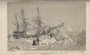
| Date: | 1838 |
|---|---|
| Description: | Position of H.M.S. Terror on the 22nd of February, 1837. The sailing ship was immobilized in the sea ice near Southampton Island, at the entrance to... |
If you didn't find the material you searched for, our Library Reference Staff can help.
Call our reference desk at 608-264-6535 or email us at: