 Filter: Categories of Wisconsin Historical Images
Filter: Subject of Ocean
Filter: Year of 1800-1899
Filter: Categories of Wisconsin Historical Images
Filter: Subject of Ocean
Filter: Year of 1800-1899
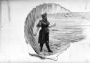
| Date: | 1898 |
|---|---|
| Description: | A woman in a bathing suit stands on the beach and holds what appears to be a seashell. The ocean is in the background. This woman is contained within a she... |

| Date: | 1866 |
|---|---|
| Description: | Exterior of Fort Sumter. A cannon has fallen on the steep shoreline and waves are hitting the rocks. Plate 58 |

| Date: | 1861 |
|---|---|
| Description: | A general map of Pennsylvania, Virginia, New Jersey and Delaware. Insets include maps of New Orleans, Baltimore, St. Louis, Charleston, Savannah, Washingto... |

| Date: | 1865 |
|---|---|
| Description: | This map of Maryland and Virginia shows railroads, rivers, cities and towns, and the positions of Confederate troops and defenses in Virginia in 1861. |

| Date: | 1860 |
|---|---|
| Description: | This colored map shows railroad lines east of the Mississippi as well as in the states bordering the Mississippi River. The Great Lakes and Gulf of Mexico ... |

| Date: | 1862 |
|---|---|
| Description: | This map of the southeastern United States shows cities and towns, rail lines, and geographic features such as rivers, mountains, lakes, and swamps. |

| Date: | 1862 |
|---|---|
| Description: | This map of the southeastern United States shows forts and battlefields, railroads, rivers, and cities and towns. Dates of admission and secession of the s... |

| Date: | 1863 |
|---|---|
| Description: | A general map of the southeastern United States showing Missouri, Kentucky, West Virginia, Virginia, North Carolina, South Carolina, Georgia, Florida, Alab... |

| Date: | 1899 |
|---|---|
| Description: | A map showing the shoreline of a portion of El Montecito, Santa Barbara County, California. The map shows properties along the Pacific Ocean, and may have ... |

| Date: | 1868 |
|---|---|
| Description: | Map showing the northern water routes between Mississippi River and Atlantic Ocean Relief shown by hachures. Includes Profile of the Erie Canal, table of ... |
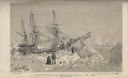
| Date: | 1838 |
|---|---|
| Description: | Position of H.M.S. Terror on the 22nd of February, 1837. The sailing ship was immobilized in the sea ice near Southampton Island, at the entrance to... |
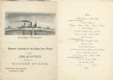
| Date: | 11 26 1898 |
|---|---|
| Description: | Menu for a "Banquet tendered by the Union Iron Works to the Delegation from the Badger State" given at the Palace Hotel, with an etching of the Battleship ... |
| Date: | 08 09 1890 |
|---|---|
| Description: | One-page menu from the R.M.S.S. Magdalena of the Royal Mail Steam Packet Company, with a parrot and a cockatiel perched on a branch above the compan... |
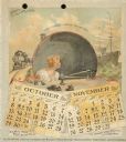
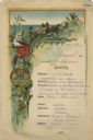
| Date: | 1893 |
|---|---|
| Description: | 1893 calendar with the months of October and November. Features an illustration of a woman sitting at a desk using a telegraph key, near the words: "The Ca... |
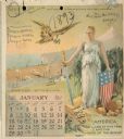
| Date: | 1893 |
|---|---|
| Description: | Calendar front, with the month of January, 1893. At the top it reads: "1893 calendar presented to the farmers of the world with the compliments of Aultman,... |

| Date: | 1868 |
|---|---|
| Description: | This map is one of the earliest weather maps of the United States, which traced an 1859 storm across the continent. Manuscript annotations in red ink show ... |

| Date: | 1895 |
|---|---|
| Description: | Map showing the continents of the world with the Americas at the center. From left to right land masses names are: "Siberia, Chinese Empire, Australia, Nor... |

| Date: | 1891 |
|---|---|
| Description: | Frederick Layton standing on deck smoking a cigar while at sea in a Kodak #2 camera portrait by T.W. Ingersoll from St. Paul, Minnesota. The photographer's... |

| Date: | 1878 |
|---|---|
| Description: | This lithograph shows Greenland, North America, Central America, South America, Polynesia, Australia, the Pacific Ocean, the Atlantic Ocean, the Arctic Oce... |

| Date: | 1878 |
|---|---|
| Description: | This lithograph shows Africa, Europe, Asia, Australia, and the Antarctic Continent, the Atlantic Ocean, the Indian Ocean, the Arctic Ocean, the Pacific Oce... |
If you didn't find the material you searched for, our Library Reference Staff can help.
Call our reference desk at 608-264-6535 or email us at: