 Filter: Categories of Wisconsin Historical Images
Filter: Subject of Ocean
Filter: Subject of writing
Filter: Categories of Wisconsin Historical Images
Filter: Subject of Ocean
Filter: Subject of writing
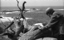
| Date: | 1968 |
|---|---|
| Description: | Ansel Adams takes exposure notes during a photo shoot at Point Lobos. |

| Date: | 1769 |
|---|---|
| Description: | Double hemispherical map showing the continents, islands, countries, and a few major cities of the world. The routes of a few explorers are depicted and la... |

| Date: | 1762 |
|---|---|
| Description: | Map including the land and islands surrounding the Gulf of Mexico. The regions and islands are labeled, as are a few rivers and cities. This map was engrav... |
If you didn't find the material you searched for, our Library Reference Staff can help.
Call our reference desk at 608-264-6535 or email us at: