 Filter: Categories of Wisconsin Historical Images
Filter: Subject of Ocean
Filter: Subject of trees
Filter: Subject of intellectual life
Filter: Categories of Wisconsin Historical Images
Filter: Subject of Ocean
Filter: Subject of trees
Filter: Subject of intellectual life

| Date: | 1893 |
|---|---|
| Description: | Front and back covers of an advertising brochure for the New Empire line of mowers, reapers and grain binders manufactured by J.F. Seiberling & Company. Th... |

| Date: | 1968 |
|---|---|
| Description: | Ansel Adams takes exposure notes during a photo shoot at Point Lobos. |

| Date: | |
|---|---|
| Description: | Bird's-eye view lithograph of Key West with ships and smaller boats in the surrounding waters. |
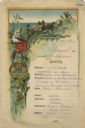
| Date: | 08 09 1890 |
|---|---|
| Description: | One-page menu from the R.M.S.S. Magdalena of the Royal Mail Steam Packet Company, with a parrot and a cockatiel perched on a branch above the compan... |

| Date: | 1715 |
|---|---|
| Description: | One of Herman Moll's most famous maps, often referred to as The Codfish Map, it shows rivers and portages, cities, Indian villages, wind directions, routes... |

| Date: | 1780 |
|---|---|
| Description: | This map shows the townships, parishes, cities, towns, plantations, lakes, rivers, swamps, and roads near the coast of South Carolina and Georgia. Emphasis... |

| Date: | 1746 |
|---|---|
| Description: | Detailed map of the western hemisphere and part of Africa and Europe. Islands, cities, settlements, rivers, lakes, countries, and regions are marked. Mount... |

| Date: | 1719 |
|---|---|
| Description: | This extremely detailed and ornate map shows the cities, Native American land, mountains, lakes, rivers, and European claims of North America. An inset map... |
If you didn't find the material you searched for, our Library Reference Staff can help.
Call our reference desk at 608-264-6535 or email us at: