 Filter: Categories of Wisconsin Historical Images
Filter: Subject of Ocean
Filter: Subject of shorelines
Filter: Subject of roads
Filter: Categories of Wisconsin Historical Images
Filter: Subject of Ocean
Filter: Subject of shorelines
Filter: Subject of roads

| Date: | |
|---|---|
| Description: | View of Plymouth Street looking towards the waterfront with large trees along the sidewalks. |

| Date: | 1899 |
|---|---|
| Description: | A map showing the shoreline of a portion of El Montecito, Santa Barbara County, California. The map shows properties along the Pacific Ocean, and may have ... |
| Date: | 02 05 1944 |
|---|---|
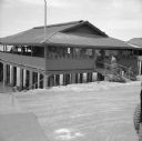
| Description: | View from road of the exterior of the Allied Officers' Club in Port Moresby, New Guinea (present day Papua New Guinea). It is built on posts above the wate... |

| Date: | 1780 |
|---|---|
| Description: | This map shows the townships, parishes, cities, towns, plantations, lakes, rivers, swamps, and roads near the coast of South Carolina and Georgia. Emphasis... |
If you didn't find the material you searched for, our Library Reference Staff can help.
Call our reference desk at 608-264-6535 or email us at: