 Filter: Categories of Wisconsin Historical Images
Filter: Subject of Ocean
Filter: Subject of railroads
Filter: Categories of Wisconsin Historical Images
Filter: Subject of Ocean
Filter: Subject of railroads

| Date: | 1886 |
|---|---|
| Description: | Advertisement for the Atchison, Topeka and Santa Fe Railroad featuring an illustration of Uncle Sam stretched from the Missouri River to the Pacific Ocean.... |

| Date: | 1850 |
|---|---|
| Description: | [... through northern United States from New York to Minnesota]. Lithography by T. Sinclair. From Perrault papers, Lucien S. Hanks, donor. |
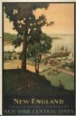
| Date: | 1947 |
|---|---|
| Description: | An original lithograph promoting New York Central Lines railway and the area of New England, deemed "America's Historic Summerland" in the poster. Featurin... |

| Date: | 1860 |
|---|---|
| Description: | This colored map shows railroad lines east of the Mississippi as well as in the states bordering the Mississippi River. The Great Lakes and Gulf of Mexico ... |

| Date: | 1862 |
|---|---|
| Description: | This map of the southeastern United States shows cities and towns, rail lines, and geographic features such as rivers, mountains, lakes, and swamps. |

| Date: | 1862 |
|---|---|
| Description: | This map of the southeastern United States shows forts and battlefields, railroads, rivers, and cities and towns. Dates of admission and secession of the s... |

| Date: | 1918 |
|---|---|
| Description: | Map showing Aleppo, Zor, Syria, Lebanon, Beirut, Jerusalem, with an inset map of the Sinai Peninsula and Egyptian frontier. Also shows the locations of rai... |
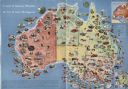
| Date: | 1950 |
|---|---|
| Description: | Color illustrated map of Australia shows various resources available in the different regions of Australia. Original caption: "Australia is the the mi... |
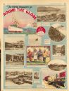
| Date: | 11 23 1930 |
|---|---|
| Description: | Full page illustrated article in the Milwaukee Journal titled "The World Voyagers go Round The Globe by Radio and Roto." Included are photographs an... |
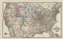
| Date: | 1878 |
|---|---|
| Description: | This map shows railroad lines, states, cities, rivers, and a small portion of Canada and Mexico. States appear in pink, yellow, and green. The Gulf of Mexi... |

| Date: | 1871 |
|---|---|
| Description: | A map of California showing railroad lines and reservations. |

| Date: | 1864 |
|---|---|
| Description: | A map of Sherman's March from Atlanta, Georgia to Goldsboro, North Carolina. |

| Date: | 1867 |
|---|---|
| Description: | A map and profile map of the railroad line from Omaha to San Francisco. |
If you didn't find the material you searched for, our Library Reference Staff can help.
Call our reference desk at 608-264-6535 or email us at: